Approximate Location Map
Large Map »
Latitude: 53.7363 / 53°44'10"N
Longitude: -2.9595 / 2°57'34"W
OS Eastings: 336804
OS Northings: 427080
OS Grid: SD368270
Mapcode National: GBR 7TS7.2D
Mapcode Global: WH85P.HCY1
Plus Code: 9C5VP2PR+G6
Entry Name: 10, East Beach
Listing Date: 13 January 1971
Last Amended: 15 February 1993
Grade: II
Source: Historic England
Source ID: 1218636
English Heritage Legacy ID: 385241
ID on this website: 101218636
Location: Lytham, Fylde, Lancashire, FY8
County: Lancashire
District: Fylde
Electoral Ward/Division: Clifton
Parish: Non Civil Parish
Built-Up Area: Lytham St Anne's
Traditional County: Lancashire
Lieutenancy Area (Ceremonial County): Lancashire
Church of England Parish: Lytham St John the Divine
Church of England Diocese: Blackburn
Tagged with: Building
This list entry was subject to a Minor Amendment on 07/02/2020
SD3627SE
621-1/6/25
LYTHAM ST ANNES
Lytham
EAST BEACH (north side)
No.10
(Formerly listed as No.10, CENTRAL BEACH, previously listed as: EAST BEACH, Lytham (north side) Nos.10 and 11, The Coppice)
13/01/71
GV
II
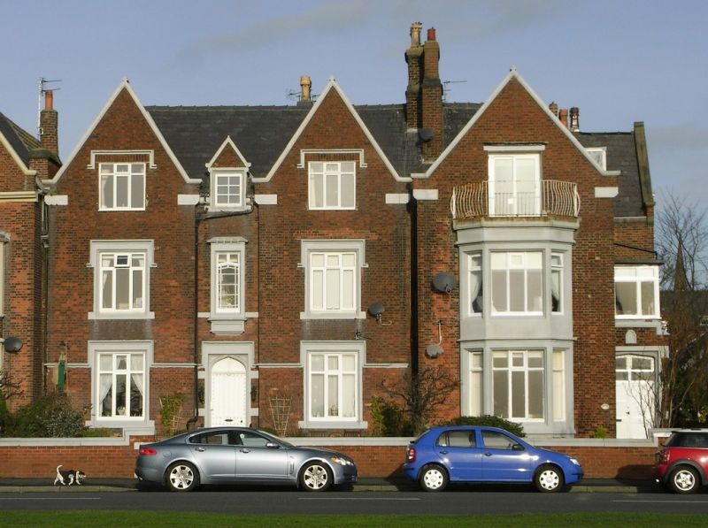
Marine villa or lodging house, now flats. Mid C19, altered. Brown brick in Flemish bond, with sandstone dressings and slate roof. Irregular double-depth plan with back extension (interlocked with No.11 to the right). Tudor style.
Two and a half storeys, 1:1:1 windows, symmetrical, with gabled outer bays flanking a very narrow centre with a gablet. The centre has a Tudor-arched doorway with stone surround under a rectangular lintel with a hoodmould, a tall rectangular oriel at first floor with a panelled apron, weathered sill and cornice, and glazing with margin panes and two-pane overlight, and above this a half-dormer with a two-light casement window. The outer bays have large transomed six-light casements, all with hoodmoulds and those at ground floor with returned ends run out as a band, and all except those at attic level (which have altered glazing) with chamfered stone surrounds.
Forms group with No.9 attached to the left (q.v.) and with No.11 attached to the right (q.v.), and is part of a noteworthy mid-C19 seaside development of villas and boarding houses.
Listing NGR: SD3680427080
External links are from the relevant listing authority and, where applicable, Wikidata. Wikidata IDs may be related buildings as well as this specific building. If you want to add or update a link, you will need to do so by editing the Wikidata entry.


Other nearby listed buildings
