Approximate Location Map
Large Map »
Latitude: 51.2698 / 51°16'11"N
Longitude: 0.526 / 0°31'33"E
OS Eastings: 576310
OS Northings: 155323
OS Grid: TQ763553
Mapcode National: GBR PR7.7TZ
Mapcode Global: VHJMF.2BGX
Plus Code: 9F327G9G+WC
Entry Name: The Pilot Public House
Listing Date: 2 August 1974
Grade: II
Source: Historic England
Source ID: 1225548
English Heritage Legacy ID: 421905
Also known as: The Pilot, Maidstone
Pilot
ID on this website: 101225548
Location: Maidstone, Kent, ME15
County: Kent
District: Maidstone
Electoral Ward/Division: High Street
Parish: Non Civil Parish
Built-Up Area: Maidstone
Traditional County: Kent
Lieutenancy Area (Ceremonial County): Kent
Tagged with: Pub
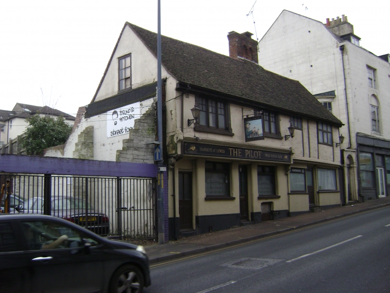
UPPER STONE STREET
5
1.
5278
(East Side)
No 25
(The Pilot Public House)
No 27
TQ 7655 SW 7/57
II GV
2.
One building. 2 storeys. Timber-framed, no 25 wholly refronted with stucco
but some timbering with painted brick infilling visible on the lst floor of
no 27. Tiled roof. 4 modern windows and modern shopfronts.
Nos 25 to 31 (odd) form a group.
Listing NGR: TQ7503055132
External links are from the relevant listing authority and, where applicable, Wikidata. Wikidata IDs may be related buildings as well as this specific building. If you want to add or update a link, you will need to do so by editing the Wikidata entry.


Other nearby listed buildings
