Approximate Location Map
Large Map »
Latitude: 52.4639 / 52°27'50"N
Longitude: -2.2018 / 2°12'6"W
OS Eastings: 386387
OS Northings: 285129
OS Grid: SO863851
Mapcode National: GBR 1BW.G51
Mapcode Global: VH91G.SBCH
Plus Code: 9C4VFQ7X+H7
Entry Name: Tailbridge, Stourton Lock no 2
Listing Date: 10 February 1995
Grade: II
Source: Historic England
Source ID: 1232634
English Heritage Legacy ID: 408007
ID on this website: 101232634
Location: Stourton, South Staffordshire, DY7
County: Staffordshire
District: South Staffordshire
Civil Parish: Kinver
Built-Up Area: Stourton
Traditional County: Staffordshire
Lieutenancy Area (Ceremonial County): Staffordshire
Church of England Parish: Kinver St Peter
Church of England Diocese: Lichfield
Tagged with: Lock
SO 88 NE
9/10008
KINVER
Stourton
Four Locks
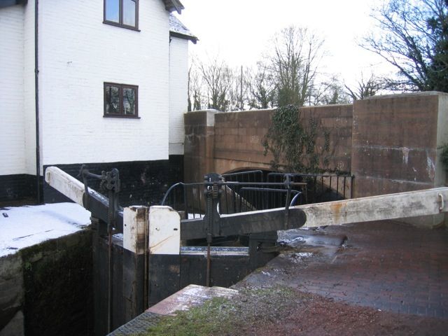
Tailbridge, Stourton Lock no 2
GV
II
Tailbridge. Early C19. Small footbridge over bottom of lock. Cast iron cantilevered arched panels with a central gap. Brick footings. Deck resurfaced. Known as a split bridge, which allowed tow rope to remain attached to the boat.
Listing NGR: SO8638785129
External links are from the relevant listing authority and, where applicable, Wikidata. Wikidata IDs may be related buildings as well as this specific building. If you want to add or update a link, you will need to do so by editing the Wikidata entry.


Other nearby listed buildings
