Approximate Location Map
Large Map »
Latitude: 50.7949 / 50°47'41"N
Longitude: -1.1192 / 1°7'9"W
OS Eastings: 462172
OS Northings: 99849
OS Grid: SZ621998
Mapcode National: GBR VLK.1R
Mapcode Global: FRA 86JZ.ZRC
Plus Code: 9C2WQVVJ+X8
Entry Name: 88, High Street
Listing Date: 20 April 1983
Grade: II
Source: Historic England
Source ID: 1233628
English Heritage Legacy ID: 409007
ID on this website: 101233628
Location: Gosport, Hampshire, PO12
County: Hampshire
District: Gosport
Electoral Ward/Division: Town
Parish: Non Civil Parish
Built-Up Area: Gosport
Traditional County: Hampshire
Lieutenancy Area (Ceremonial County): Hampshire
Church of England Parish: Gosport Holy Trinity
Church of England Diocese: Portsmouth
Tagged with: Building
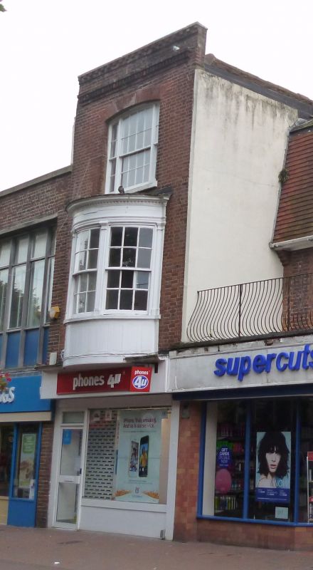
HIGH STREET
1.
5232 (south side)
No 88
SZ 6299 NW 8/64
II
2.
C18. Three-storeys, ground floor modern shop. Red brickwork in Flemish bond;
parapet, brick dentil cornice. Fine first floor bow window.
Listing NGR: SZ6217099839
External links are from the relevant listing authority and, where applicable, Wikidata. Wikidata IDs may be related buildings as well as this specific building. If you want to add or update a link, you will need to do so by editing the Wikidata entry.


Other nearby listed buildings
