Approximate Location Map
Large Map »
Latitude: 51.1419 / 51°8'30"N
Longitude: 0.2123 / 0°12'44"E
OS Eastings: 554851
OS Northings: 140394
OS Grid: TQ548403
Mapcode National: GBR MPQ.6J6
Mapcode Global: VHHQC.MKKH
Plus Code: 9F3246R6+PW
Entry Name: Burnt House Sandstones
Listing Date: 24 August 1990
Grade: II
Source: Historic England
Source ID: 1240936
English Heritage Legacy ID: 439525
ID on this website: 101240936
Location: Bullingstone, Tunbridge Wells, Kent, TN3
County: Kent
District: Tunbridge Wells
Civil Parish: Speldhurst
Built-Up Area: Bullingstone
Traditional County: Kent
Lieutenancy Area (Ceremonial County): Kent
Church of England Parish: Speldhurst St Mary the Virgin
Church of England Diocese: Rochester
Tagged with: Architectural structure
TQ 54 S SPELDHURST LANGTON ROAD, SPELDHURST
3/533 Burnt House and Sandstones
II
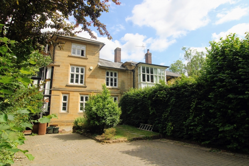
House, divided into 2. Mid/late C19 possibly a recasting of an earlier house.
Local sandstone ashlar, each block hammer-dressed with a plain border; slate
roof; stacks with brick shafts. Stylistically eclectic with Tudor style
windows but classical masonry detail.
Plan: Approximately rectangular double depth plan, the entrance elevation
facing south west, the north west elevation overlooking Langton Road.
Sandstones is to the north east, Burnt House to the south west preserving the
original entrance. Entrance to Sandstones on the north west elevation, dating
form the 1960s, when the property was divided. Details of plan unclear on
survey as interior not inspected.
Exterior: Mostly 2 storeys with a 3-storey block to the north (Sandstones).
Hipped roofs. Platband at first floor level; deep eaves; painted mullion and
transom windows, most with elliptical arched heads to the upper lights, the
frames chamfered with stone sills, glazed with large-pane casements.
Asymmetrical 3-window south west front, the 2 left hand bays broken forward
under a lean-to roof. Front door in the centre bay with a recessed porch, and
a 4-panel outer door with an overlight flanked by glazed panels. Above the
front door a section of imitation timber-framing below a 4-light window. 3-
light windows, one to each floor, in the left hand bay. The right hand bay,
set back, has one first floor 3-light window and a C20 ground floor casement.
The north west elevation is more irregular 4-bays and rises to 3 storeys at
the left end, with 2 projecting 2-storey bays to the right, the first bay from
the right with a hipped roof, coved cornice and stone plinth with a section of
imitation framing between the first and ground floor windows, which are 6-
light plus one-light to each return. The right hand bay has one first and one
ground floor 3-light window. 1960s 2-panel door in the second bay from the
right, converted from an original 3-light mullion and transom window; similar
first floor window above. Similar windows to the 3-storey block at the left
end.
Interior: Not inspected.
Listing NGR: TQ5485140394
External links are from the relevant listing authority and, where applicable, Wikidata. Wikidata IDs may be related buildings as well as this specific building. If you want to add or update a link, you will need to do so by editing the Wikidata entry.


Other nearby listed buildings
