Approximate Location Map
Large Map »
Latitude: 51.2821 / 51°16'55"N
Longitude: 1.0748 / 1°4'29"E
OS Eastings: 614526
OS Northings: 158153
OS Grid: TR145581
Mapcode National: GBR TY2.GKD
Mapcode Global: VHLGM.L12G
Plus Code: 9F3373JF+RW
Entry Name: 14 and 15, St Dunstan's Street
Listing Date: 7 September 1973
Grade: II
Source: Historic England
Source ID: 1241789
English Heritage Legacy ID: 441026
ID on this website: 101241789
Location: Canterbury, Kent, CT2
County: Kent
District: Canterbury
Electoral Ward/Division: Westgate
Parish: Non Civil Parish
Built-Up Area: Canterbury
Traditional County: Kent
Lieutenancy Area (Ceremonial County): Kent
Tagged with: Building
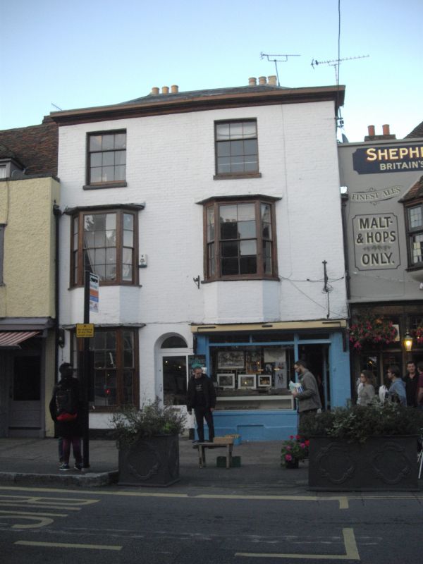
1.
944 ST DUNSTAN'S STREET
(North East Side)
Nos 14 & 15
TR 1458 SE 2/739
II GV
2.
Early C19 facade. 3 storeys painted brick. Hipped slate roof. 2 sashes
with glazing bars intact. 1st floor has 2 3-light bays With some glazing
bars intact. Ground floor has later shopfronts. Doors have round-headed doorcases.
The rear elevation has a roof in 2 hips and C18 sashes.
Nos 5 to 16 (consec) form a group.
Listing NGR: TR1453458160
External links are from the relevant listing authority and, where applicable, Wikidata. Wikidata IDs may be related buildings as well as this specific building. If you want to add or update a link, you will need to do so by editing the Wikidata entry.


Other nearby listed buildings
