Approximate Location Map
Large Map »
Latitude: 53.6826 / 53°40'57"N
Longitude: -1.505 / 1°30'17"W
OS Eastings: 432793
OS Northings: 420798
OS Grid: SE327207
Mapcode National: GBR KTXV.ZM
Mapcode Global: WHC9Z.VPJP
Plus Code: 9C5WMFMW+22
Entry Name: The former Milnes' Orangery, formerly the Unitarian Chapel Hall
Listing Date: 30 March 1971
Last Amended: 6 December 2023
Grade: II*
Source: Historic England
Source ID: 1242123
English Heritage Legacy ID: 441425
Also known as: Milnes' Orangery
ID on this website: 101242123
Location: St Johns, Wakefield, West Yorkshire, WF1
County: Wakefield
Electoral Ward/Division: Wakefield North
Parish: Non Civil Parish
Built-Up Area: Wakefield
Traditional County: Yorkshire
Lieutenancy Area (Ceremonial County): West Yorkshire
Church of England Parish: Wakefield St John the Baptist
Church of England Diocese: Leeds
Tagged with: Orangery
Former orangery built around 1800, most likely about 1810, in neoclassical ‘Adam’ style for Pemberton House on Westgate. After 1849, by which time it had been extended, used as a Sunday School and non-sectarian day school associated with Westgate Unitarian Chapel. Converted to offices in the late C20.
Former orangery, late C18 or early C19, for Mary Bridget, Dowager Viscountess of Galloway, daughter of Pemberton Milnes. Converted into a school mid-C19 by Westgate Unitarian Chapel, converted to offices late C20.
MATERIALS: stone ashlar and stucco, red-brown brick to the rear, stone stacks, Welsh slate roofs.
PLAN: the original central block has its long principal elevation facing south, set back and at an angle to Back Lane. It is extended with a parallel range to the rear and is flanked by later wings, entrances being via these wings.
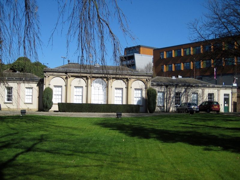
EXTERIOR: a single-storey structure with hipped roofs constructed in the neoclassical ‘Adam’ style.
South elevation: this has a five-bay arcaded central section (the original orangery) flanked by two smaller ranges each of five bays, these wings being slightly set back. The central section is framed in an order of ashlar engaged columns with feather capitals, supporting a frieze of garlands and paterae with a dentil cornice above. Between the columns there are stone arches with moulded imposts, the central arch being glazed, retaining narrow glazing bars, the flanking archways having stuccoed infills, each containing a hornless sash window with glazing bars and a stone sill. On the right return, there is a modern inserted door.
The mainly stuccoed flanking wings are divided into bays by pilasters supporting a plain ashlar entablature, dentilated stringcourse and blocking course. The left wing has a modern central door flanked by four recessed hornless sash windows with glazing bars and stone sills. Beyond this to the left, is a small extension in stone with a flat roof. The right wing is similar to the left, but with a door inserted into the right-hand bay.
North elevation (rear): has exposed local red-brown brick to the various later additions which also feature segmental headed windows with stone sills and recessed sashes with glazing bars. The rear central extension also has a hipped roof, with two stone stacks within the valley.
INTERIOR: retains a number of sets of window shutters. The right wing has a coved, groined ceiling.
Wakefield was established during the medieval period at a strategic trading position on the river Calder, seeing the town become the capital of Yorkshire's cloth trade by the C14. During the C17 and C18, Westgate, one of the town’s four principal streets, became a popular residential district for the mercantile classes, with townhouses erected for several prosperous wool chapmen (merchants). The area suffered social and financial decline as a residential area during the C19 and C20 centuries, particularly after the opening of Westgate railway station, although the second half of the C19 saw the construction of several grand Victorian buildings. The development of Upper Westgate continued through the C20 with the growth of retail premises, both in purpose-built structures and in the conversion of existing townhouses.
Milnes’ Orangery (which is not shown on the Enclosure Map surveyed in the mid-1790s but is shown on John Walker’s map of 1823) was built as a garden building for Pemberton House on Westgate. It is thought to have been built in the late C18 or early C19 for Mary Bridget, who was the Dowager Viscountess of Galway from 1810 and was the daughter of Pemberton Milnes. Milnes (died 1795), a magistrate and Deputy Lieutenant of Yorkshire came from a leading family of cloth and wine merchants. He was a political Whig and Dissenter and a supporter of Westgate Chapel, his town residence being Pemberton House on Westgate. The Dowager Viscountess inherited Pemberton House in 1812. The Orangery was sold off separately in 1835 following her death, becoming part of a horticultural and zoological garden in 1838. In 1849 it was bought by Daniel Gaskell who then granted it to the trustees of Westgate Chapel; the building was converted into a non-sectarian day school for children of local artisans and tradesmen. A detached lodge (separately listed) was constructed in the grounds soon after. The gardens were used as a burial ground, and a service tunnel was created under Back Lane leading to the chapel’s crypt. Milnes’ Orangery was used as a private school until 1957. It was converted into offices at the end of the C20 but has been disused since about 2015.
The central block of the building is interpreted as the original orangery. The side wings are thought to have been added after 1823 and appear to be shown on the Ordnance Survey Town Plan published in 1851, although the wing to the east may date to 1860-1861 (the 'Grand Saloon' paid for by Daniel Gaskell). Various other small extensions were added subsequently.
The former Milnes’ Orangery, formerly the Unitarian Chapel Hall, is listed at Grade II* for the following principal reasons:
Architectural interest:
* a high-quality example of late Georgian architecture as a neoclassical ‘Adam’ style orangery, later sympathetically converted in the mid-C19 and reused as a school.
Historic interest:
* demonstrating the urbanisation of the area through the C19, originally being constructed as a garden building to Pemberton House and subsequently converted into a school;
* for its associations with the Dowager Viscountess of Galway and also with Westgate Unitarian Chapel, both being of special historic interest.
Group value:
* with Pemberton House, for which it was originally built, with the Westgate Unitarian Chapel which acquired the building in the mid-C19, and with the memorials that were subsequently erected in the grounds.
External links are from the relevant listing authority and, where applicable, Wikidata. Wikidata IDs may be related buildings as well as this specific building. If you want to add or update a link, you will need to do so by editing the Wikidata entry.


Other nearby listed buildings
