Approximate Location Map
Large Map »
Latitude: 51.2761 / 51°16'33"N
Longitude: 1.0775 / 1°4'38"E
OS Eastings: 614739
OS Northings: 157492
OS Grid: TR147574
Mapcode National: GBR TY2.WS3
Mapcode Global: VHLGM.M6G2
Plus Code: 9F3373GG+CX
Entry Name: 4-7, St Mary's Street
Listing Date: 7 September 1973
Grade: II
Source: Historic England
Source ID: 1242175
English Heritage Legacy ID: 441540
ID on this website: 101242175
Location: Canterbury, Kent, CT1
County: Kent
District: Canterbury
Electoral Ward/Division: Westgate
Parish: Non Civil Parish
Built-Up Area: Canterbury
Traditional County: Kent
Lieutenancy Area (Ceremonial County): Kent
Tagged with: Building
1.
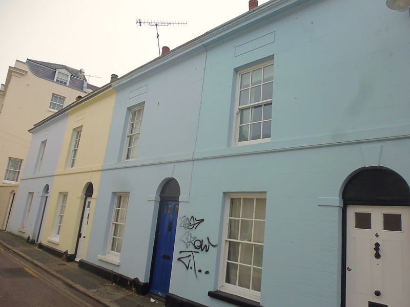
944 ST MARY'S STREET
(South West Side)
Nos 4 to 7 (consec)
TR 1457 SE 8/673
II
2.
Early C19, 2 storeys brick, cement rendered on front elevation. Slate roof.
Stone parapet with moulded stone cornice. Stringcourse. 4 sashes with glazing
bars intact. Blank panels above 1st floor windows. Stringcourse. Round-headed
doorcases with keystones and panelled doors. Plinth. Footscrapers.
Nos 1 to 7 (consec) form a group.
Listing NGR: TR1473257494
External links are from the relevant listing authority and, where applicable, Wikidata. Wikidata IDs may be related buildings as well as this specific building. If you want to add or update a link, you will need to do so by editing the Wikidata entry.


Other nearby listed buildings
