Approximate Location Map
Large Map »
Latitude: 51.4407 / 51°26'26"N
Longitude: 0.7683 / 0°46'5"E
OS Eastings: 592490
OS Northings: 174940
OS Grid: TQ924749
Mapcode National: GBR RS2.P2D
Mapcode Global: VHKJ7.81JV
Plus Code: 9F32CQR9+78
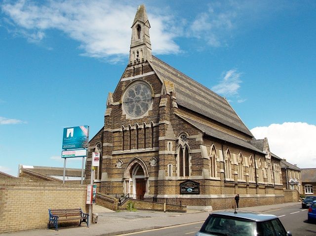
Entry Name: Roman Catholic Church of St Henry and St Elizabeth
Listing Date: 30 June 1978
Grade: II
Source: Historic England
Source ID: 1242869
English Heritage Legacy ID: 443873
ID on this website: 101242869
Location: Sheerness, Swale, Kent, ME12
County: Kent
District: Swale
Electoral Ward/Division: Sheerness
Parish: Sheerness
Built-Up Area: Sheerness
Traditional County: Kent
Lieutenancy Area (Ceremonial County): Kent
Tagged with: Church building
THE BROADWAY
1.
5282
(North Side)
Mile Town, Sheerness
Roman Catholic Church
of St Henry and
St Elizabeth
TQ 9274 NW 9/5
TQ 97 SW 11/5
II
2.
Dated 1863-4 by Edward Welby Pugin. Built of stock brick with black brick bands. Slate roof. The west end has a bellcote. North and south aisles. 5 bay nave.
Listing NGR: TQ9249074940
External links are from the relevant listing authority and, where applicable, Wikidata. Wikidata IDs may be related buildings as well as this specific building. If you want to add or update a link, you will need to do so by editing the Wikidata entry.


Other nearby listed buildings
