Approximate Location Map
Large Map »
Latitude: 51.2747 / 51°16'29"N
Longitude: 1.0738 / 1°4'25"E
OS Eastings: 614494
OS Northings: 157332
OS Grid: TR144573
Mapcode National: GBR TY8.29Z
Mapcode Global: VHLGM.K7K3
Plus Code: 9F3373FF+VG
Entry Name: 14 and 16, Wincheap
Listing Date: 7 September 1973
Grade: II
Source: Historic England
Source ID: 1242967
English Heritage Legacy ID: 444112
ID on this website: 101242967
Location: Canterbury, Kent, CT1
County: Kent
District: Canterbury
Electoral Ward/Division: Westgate
Parish: Non Civil Parish
Built-Up Area: Canterbury
Traditional County: Kent
Lieutenancy Area (Ceremonial County): Kent
Tagged with: Building
1.
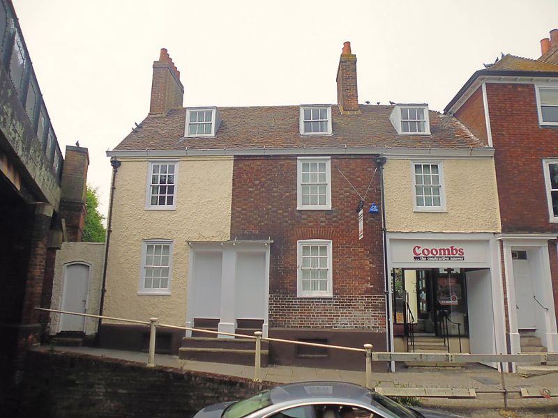
944 WINCHEAP
(North West Side)
Nos 14 and 16
TR 1457 SW 7/356
II
2.
Formerly shown as Nos 6 and 7.
Mid C18 fronts to probably older buildings. 2 storeys red brick but part
is now roughcast. Old tiled roof with 3 dormers. 3 sashes with glazing bars
intact. Left side double doorcase with vestigial hood and 4 steps to street
level. Right side carriage entrance.
Listing NGR: TR1449157336
External links are from the relevant listing authority and, where applicable, Wikidata. Wikidata IDs may be related buildings as well as this specific building. If you want to add or update a link, you will need to do so by editing the Wikidata entry.


Other nearby listed buildings
