Approximate Location Map
Large Map »
Latitude: 51.2742 / 51°16'26"N
Longitude: 1.0724 / 1°4'20"E
OS Eastings: 614398
OS Northings: 157262
OS Grid: TR143572
Mapcode National: GBR TY8.1YX
Mapcode Global: VHLGM.J7TK
Plus Code: 9F3373FC+MX
Entry Name: 50 and 52, Wincheap
Listing Date: 7 September 1973
Grade: II
Source: Historic England
Source ID: 1242989
English Heritage Legacy ID: 444133
ID on this website: 101242989
Location: Canterbury, Kent, CT1
County: Kent
District: Canterbury
Electoral Ward/Division: Wincheap
Parish: Non Civil Parish
Built-Up Area: Canterbury
Traditional County: Kent
Lieutenancy Area (Ceremonial County): Kent
Tagged with: Building
1.
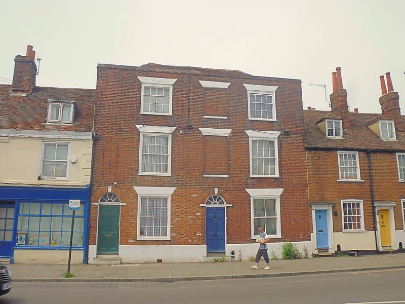
944 WINCHEAP
(North West Side)
Nos 50 and 52
TR 1457 SW 7/359
II GV
2.
C18. Originally 1 house. 3 storeys red brick. Hipped tiled roof, Stone
coping. 2 sashes 1 blank. Some glazing bars intact. Plinth. Central doorcase
with semi-circular fanlight and 6 fielded panels. No 52 has modern shop front.
Rear elevation has a roof in 2 hips.
Nos 42 to 64 (even) form a group.
Listing NGR: TR1439857262
External links are from the relevant listing authority and, where applicable, Wikidata. Wikidata IDs may be related buildings as well as this specific building. If you want to add or update a link, you will need to do so by editing the Wikidata entry.


Other nearby listed buildings
