Approximate Location Map
Large Map »
Latitude: 51.8937 / 51°53'37"N
Longitude: -2.084 / 2°5'2"W
OS Eastings: 394318
OS Northings: 221681
OS Grid: SO943216
Mapcode National: GBR 2MB.7XR
Mapcode Global: VH947.TNNP
Plus Code: 9C3VVWV8+FC
Entry Name: Carrick House
Listing Date: 12 March 1955
Grade: II
Source: Historic England
Source ID: 1245259
English Heritage Legacy ID: 474934
ID on this website: 101245259
Location: Montpellier, Cheltenham, Gloucestershire, GL50
County: Gloucestershire
District: Cheltenham
Electoral Ward/Division: Park
Parish: Non Civil Parish
Built-Up Area: Cheltenham
Traditional County: Gloucestershire
Lieutenancy Area (Ceremonial County): Gloucestershire
Church of England Parish: Leckhampton St Philip and St James
Church of England Diocese: Gloucester
Tagged with: House
This list entry was subject to a Minor Amendment on 27 February 2023 to remove superfluous source details from text, amend the description and to reformat the text to current standards
SO9421NW
630-1/17/502
CHELTENHAM
LYPIATT ROAD (East side)
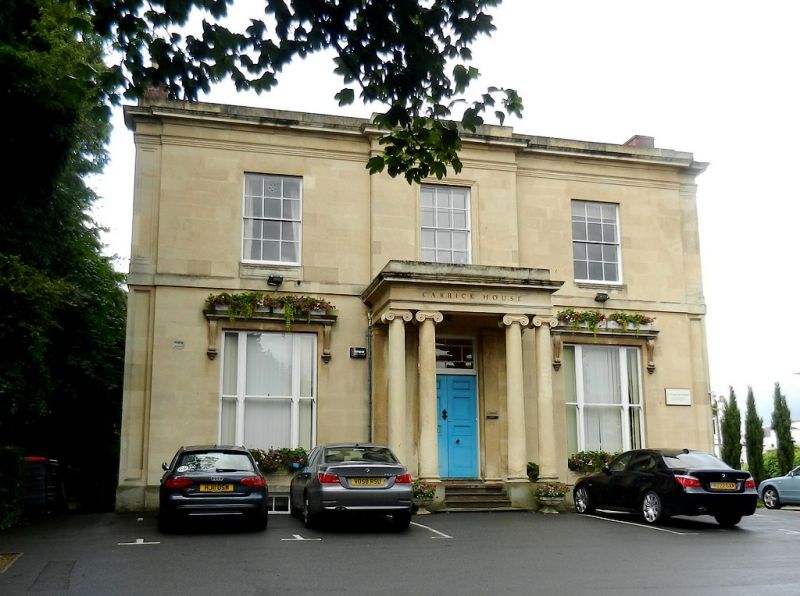
Carrick House
12/03/55
GV
II
Villa, now offices. c1826-32. Ashlar over brick with concealed roof and renewed brick end stacks. Double depth plan with central hallway and service range to rear.
EXTERIOR: two storeys, three first floor windows. Ashlar detailing includes sunk pilasters to ends. Central break forward with ground floor tetrastyle Ionic porch with architrave, frieze and cornice with blocking course. Steps to central six-panel double doors with overlight with margin glazing. Ground floor has tripartite windows with tall one/one sashes, cornice on consoles. First floor band. First floor has six/six sashes, that to centre has tooled architrave. Crowning architrave, frieze and cornice with blocking course. Right return has full-height bow with first floor band; six/six sashes and panelled aprons below (central window is blind).
INTERIOR: not inspected.
SUBSIDIARY FEATURES: bow to right has ground-floor verandah with pierced parapet.
HISTORICAL NOTE: Burlington House, Carrick House, Compass House (qv), Imperial House (qv) and Stanmer House (qv) form a distinguished group of villas along the east side of Lypiatt Road (marked on Merrett's Map of 1834 as Suffolk Lawn), all designed by Jenkins as part of the estate laid out for James Fisher and including Suffolk Square. Designs reputed to be in Gloucester Record Office.
Listing NGR: SO9432821679
External links are from the relevant listing authority and, where applicable, Wikidata. Wikidata IDs may be related buildings as well as this specific building. If you want to add or update a link, you will need to do so by editing the Wikidata entry.


Other nearby listed buildings
