Approximate Location Map
Large Map »
Latitude: 51.8626 / 51°51'45"N
Longitude: -2.2541 / 2°15'14"W
OS Eastings: 382598
OS Northings: 218249
OS Grid: SO825182
Mapcode National: GBR 1L5.0YK
Mapcode Global: VH94B.WG60
Plus Code: 9C3VVP7W+29
Entry Name: Dry Dock South of Engine House Including Crane
Listing Date: 12 March 1973
Last Amended: 15 December 1998
Grade: II
Source: Historic England
Source ID: 1245602
English Heritage Legacy ID: 472558
ID on this website: 101245602
Location: High Orchard, Gloucester, Gloucestershire, GL1
County: Gloucestershire
District: Gloucester
Electoral Ward/Division: Westgate
Parish: Non Civil Parish
Built-Up Area: Gloucester
Traditional County: Gloucestershire
Lieutenancy Area (Ceremonial County): Gloucestershire
Church of England Parish: Hempsted with Gloucester, Saint Mary de Lode and Saint Mary de Crypt
Church of England Diocese: Gloucester
Tagged with: Architectural structure
GLOUCESTER
SO8218SE THE DOCKS
844-1/11/343 Dry Dock south of Engine House,
12/03/73 including crane
(Formerly Listed as:
THE DOCKS
Dry Dock (adjacent to Alexandra
Warehouse))
GV II
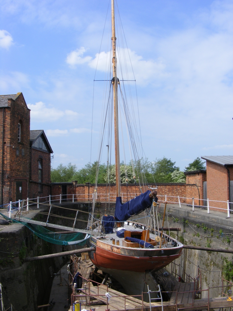
Dry or graving dock. 1852-3. Built by William Guest for the
Gloucester and Berkeley Canal Company. Brick-lined basin
capped by stone kerbs with a protective railing of slender
cast-iron bollards linked by pairs of pipe rails. Entry to
dock from the south-west side of Main Basin through a pair of
timber gates surmounted by footbridges; continuous stepped
revetments to sides and semicircular end of dock basin, with
iron late C19 crane. The dock preceded completion of the
Gloucester and Dean Forest railway line opened in 1854. It was
built in order to facilitate the repair of vessels in and the
export of coal from Gloucester, rather than go to a South
Wales port for repairs and then pick up coal for export.
(Original Drawings in Gloucestershire Records Office: D2460
Drawings 9-F).
Listing NGR: SO8259818249
External links are from the relevant listing authority and, where applicable, Wikidata. Wikidata IDs may be related buildings as well as this specific building. If you want to add or update a link, you will need to do so by editing the Wikidata entry.


Other nearby listed buildings
