Approximate Location Map
Large Map »
Latitude: 51.8638 / 51°51'49"N
Longitude: -2.2514 / 2°15'4"W
OS Eastings: 382785
OS Northings: 218382
OS Grid: SO827183
Mapcode National: GBR 1L5.1M8
Mapcode Global: VH94B.XFN3
Plus Code: 9C3VVP7X+GC
Entry Name: Herbert Warehouse
Listing Date: 12 March 1973
Grade: II
Source: Historic England
Source ID: 1245605
English Heritage Legacy ID: 472561
ID on this website: 101245605
Location: Gloucester, Gloucestershire, GL1
County: Gloucestershire
District: Gloucester
Electoral Ward/Division: Westgate
Parish: Non Civil Parish
Built-Up Area: Gloucester
Traditional County: Gloucestershire
Lieutenancy Area (Ceremonial County): Gloucestershire
Church of England Parish: Hempsted with Gloucester, Saint Mary de Lode and Saint Mary de Crypt
Church of England Diocese: Gloucester
Tagged with: Warehouse
GLOUCESTER
SO8218SE THE DOCKS
844-1/11/347 Herbert Warehouse
12/03/73
GV II
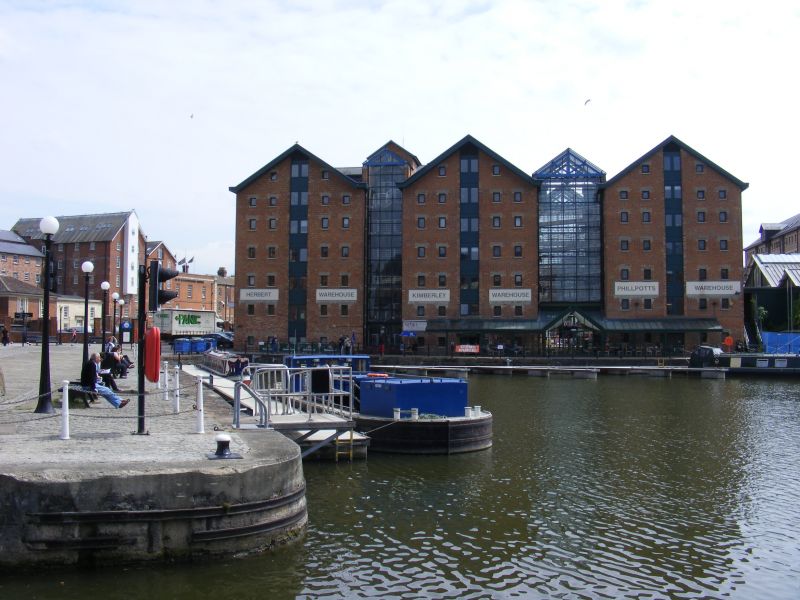
Warehouse, now local authority offices. 1846. Probably by John
Jaques of Gloucester for Samuel Herbert, solicitor, and leased
to J and C Sturge, corn merchants; 1985 restored and converted
to offices for Gloucester City Council, with addition to link
with offices in conversion of Kimberley Warehouse (qv) on the
south side. Red brick with stone lintels and sills to window
openings, renewed slate roof with skylights, barge and eaves
boards, internally hollow cast-iron columns and renewed timber
or concrete slab floors.
PLAN: a large rectangular block, with gable-end towards Main
Dock; on north side late C20 entrance door to Council offices,
with broad flight of steps to lobby at former first-floor
level, and suspended canopy above; the south side partly
masked by late C20 infill addition.
EXTERIOR: six storeys, basement and loft floor; in each side
of the block three, full-height, former loading door openings,
one in the centre and one towards each end, flanked by wall
panels (W-D-W-D-W-D-W) with four windows in each wall panel;
in each gable-end wall a central former loading door opening,
and in wall to each side two windows to each floor; all the
former loading door openings infilled with late C20 windows
and panels and, on the south side, by C20 access to adjoining
warehouse; above the central loading door opening on the north
side is a reconstructed, timber, front gabled, projecting
hoist housing supported on shaped brackets; all the windows
fitted with C20 side-hung single sashes.
INTERIOR: refitted, some cast-iron columns and in the loft
floor original queen post trusses.
(Conway-Jones H: Gloucester Docks An Illustrated History:
Gloucester: 1984-: 167).
Listing NGR: SO8278518382
External links are from the relevant listing authority and, where applicable, Wikidata. Wikidata IDs may be related buildings as well as this specific building. If you want to add or update a link, you will need to do so by editing the Wikidata entry.


Other nearby listed buildings
