Approximate Location Map
Large Map »
Latitude: 51.8617 / 51°51'42"N
Longitude: -2.2503 / 2°15'1"W
OS Eastings: 382858
OS Northings: 218151
OS Grid: SO828181
Mapcode National: GBR 1L5.7WP
Mapcode Global: VH94B.YG6P
Plus Code: 9C3VVP6X+MV
Entry Name: The Tall Ships Public House
Listing Date: 15 December 1998
Grade: II
Source: Historic England
Source ID: 1245631
English Heritage Legacy ID: 472513
Also known as: The Tall Ship, Gloucester
Tall Ship
The Tall Ship Public House
ID on this website: 101245631
Location: High Orchard, Gloucester, Gloucestershire, GL1
County: Gloucestershire
District: Gloucester
Electoral Ward/Division: Westgate
Parish: Non Civil Parish
Built-Up Area: Gloucester
Traditional County: Gloucestershire
Lieutenancy Area (Ceremonial County): Gloucestershire
Church of England Parish: Hempsted with Gloucester, Saint Mary de Lode and Saint Mary de Crypt
Church of England Diocese: Gloucester
Tagged with: Pub
GLOUCESTER
SO8218SE SOUTHGATE STREET
844-1/11/287 (West side)
No.134
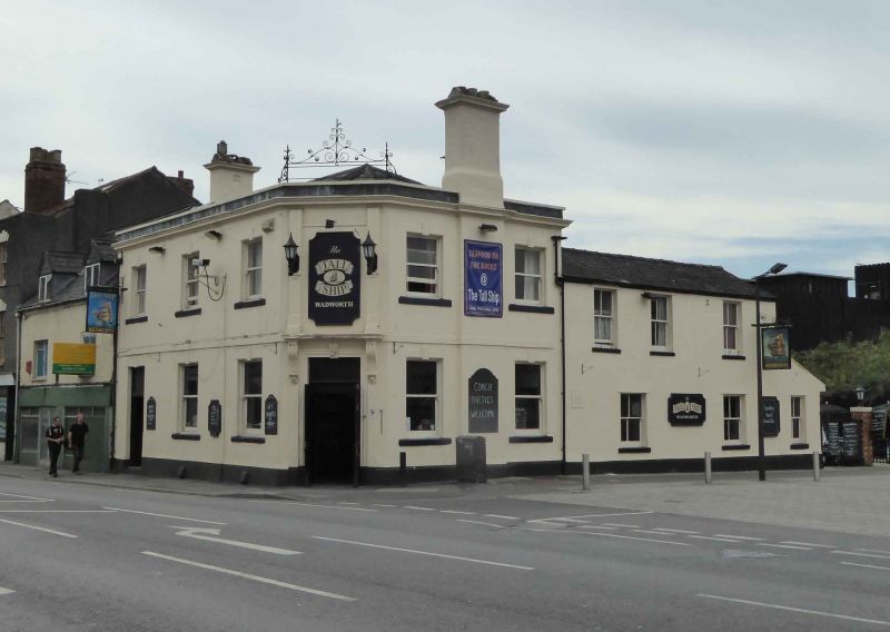
The Tall Ships Public House
GV II
Formerly known as: The British Flag SOUTHGATE STREET.
Public house. Mid to late C19, on south-west corner of
entrance to Docks from Southgate Street. Stuccoed brick with
stone details, slate roof, two stuccoed stacks. Italianate
style. Range to front with entrance in canted angle at the
corner; lower wing to rear right.
EXTERIOR: two storeys and cellar; the west and north fronts
have offset plinths, raised band at first-floor level and
moulded crowning cornice with parapet above; the entrance
doorway is framed by a moulded architrave with a carved key
stone in the lintel and pilasters with moulded brackets
supporting a cornice; on first floor above the doorway
panelled pilasters frame a window concealed by a sign; on the
front in Southgate Street three plain sashes on the ground
floor in plain stone frames with projecting and raised key
stones in the lintels and projecting stone sills; on the first
floor three similar but slightly smaller sashes in similar
frames; on the front facing the entry to the docks a central
projecting chimney-stack capped by a moulded cornice; on
either side of the stack on each floor a sash in a frame
matching the windows in Southgate Street, The wing at the rear
has irregular fenestration with three similar sashes on each
floor. On the parapet over the canted angle a wrought-iron
frame with decorative brackets and cresting.
INTERIOR: altered on ground floor.
An externally complete public house of this date historically
linked with and prominently sited close to The Docks (qv) to
the north-west.
Listing NGR: SO8285818151
External links are from the relevant listing authority and, where applicable, Wikidata. Wikidata IDs may be related buildings as well as this specific building. If you want to add or update a link, you will need to do so by editing the Wikidata entry.


Other nearby listed buildings
