Approximate Location Map
Large Map »
Latitude: 51.8641 / 51°51'50"N
Longitude: -2.2492 / 2°14'57"W
OS Eastings: 382935
OS Northings: 218418
OS Grid: SO829184
Mapcode National: GBR 1L5.260
Mapcode Global: VH94B.YDSV
Plus Code: 9C3VVQ72+J8
Entry Name: 17, Ladybellegate Street
Listing Date: 23 January 1952
Last Amended: 15 December 1998
Grade: II*
Source: Historic England
Source ID: 1245754
English Heritage Legacy ID: 472245
ID on this website: 101245754
Location: Gloucester, Gloucestershire, GL1
County: Gloucestershire
District: Gloucester
Electoral Ward/Division: Westgate
Parish: Non Civil Parish
Built-Up Area: Gloucester
Traditional County: Gloucestershire
Lieutenancy Area (Ceremonial County): Gloucestershire
Church of England Parish: Hempsted with Gloucester, Saint Mary de Lode and Saint Mary de Crypt
Church of England Diocese: Gloucester
Tagged with: Building
GLOUCESTER
SO8218SE LADYBELLEGATE STREET
844-1/11/149 (East side)
23/01/52 No.17
(Formerly Listed as:
LADYBELLEGATE STREET
Part of No.11 (occupied by
Gloucester Printers Ltd) and Nos 13
to 17 (odd))
GV II*
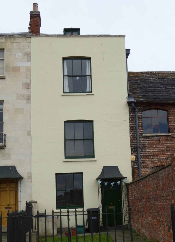
House. One of three houses in early C19 terrace incorporating
remains of the C13 west range of the former Dominican friary,
Blackfriars (qv), altered c1540 for Sir Thomas Bell, later C19
alterations, remodelled and restored late C20 by English
Heritage. Brick with stuccoed front, stone rubble, slate roof,
brick stack. Double-depth block within width of C13 range.
EXTERIOR: three storeys and attic; a single bay with a stone
coped parapet. On the ground floor the entrance doorway to
right and a single sash with vertical glazing bars (3 panes)
to left; a central sash with similar glazing on both of the
upper floors in openings with segmental arched heads and
projecting stone sills. The rear (east wall) is of C13 rubble
to approximately half its height.
INTERIOR: remains of C13 rubble walls exposed in the cellar.
Listing NGR: SO8293518418
External links are from the relevant listing authority and, where applicable, Wikidata. Wikidata IDs may be related buildings as well as this specific building. If you want to add or update a link, you will need to do so by editing the Wikidata entry.


Other nearby listed buildings
