Approximate Location Map
Large Map »
Latitude: 51.8645 / 51°51'52"N
Longitude: -2.249 / 2°14'56"W
OS Eastings: 382949
OS Northings: 218461
OS Grid: SO829184
Mapcode National: GBR 1L5.26Y
Mapcode Global: VH94B.YDXK
Plus Code: 9C3VVQ72+Q9
Entry Name: Boundary Wall to North West Corner of Friary Site, Blackfriars
Listing Date: 12 March 1973
Last Amended: 15 December 1998
Grade: II*
Source: Historic England
Source ID: 1245990
English Heritage Legacy ID: 472093
ID on this website: 101245990
Location: Gloucester, Gloucestershire, GL1
County: Gloucestershire
District: Gloucester
Electoral Ward/Division: Westgate
Parish: Non Civil Parish
Built-Up Area: Gloucester
Traditional County: Gloucestershire
Lieutenancy Area (Ceremonial County): Gloucestershire
Church of England Parish: Hempsted with Gloucester, Saint Mary de Lode and Saint Mary de Crypt
Church of England Diocese: Gloucester
Tagged with: Wall
GLOUCESTER
SO8218SE BLACKFRIARS
844-1/11/13 (South side)
12/03/73 Boundary Wall to north-west corner
of Friary Site, Blackfriars
(Formerly Listed as:
LADYBELLEGATE STREET
Wall enclosing No.11)
GV II*
Includes: Boundary Wall to north-west corner of Friary Site,
Blackfriars LADYBELLEGATE STREET.
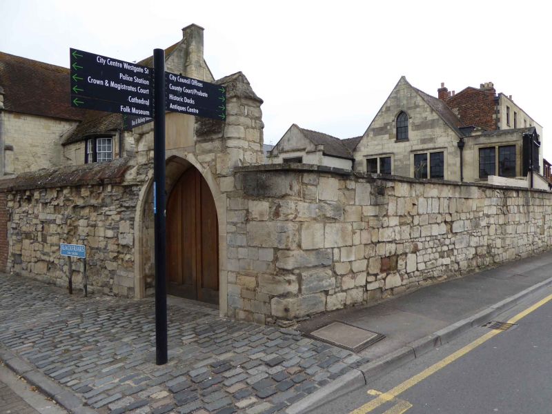
Boundary wall enclosing the north-west corner of the site of
the former Dominican friary (Blackfriars), on the south side
of Blackfriars and the east side of Ladybellegate Street; now
part of the ancient monument which includes Blackfriars Church
(qv). 1540-45 for Sir Thomas Bell and repaired at various
dates. Reused medieval worked stones and rubble partly laid in
courses, brick repairs; stone weathered copings. In the wall
facing Blackfriars close to the corner a gateway with pointed
arch and an outer, continuous, hollow moulding to the splayed
jambs and arch; a coped parapet above the gateway. 6m to the
east a second arched gateway of brick with a stone inset above
the arch, the stone inscribed "Blackfriars Square".
Listing NGR: SO8294918461
External links are from the relevant listing authority and, where applicable, Wikidata. Wikidata IDs may be related buildings as well as this specific building. If you want to add or update a link, you will need to do so by editing the Wikidata entry.


Other nearby listed buildings
