Approximate Location Map
Large Map »
Latitude: 51.5015 / 51°30'5"N
Longitude: -0.1571 / 0°9'25"W
OS Eastings: 528009
OS Northings: 179675
OS Grid: TQ280796
Mapcode National: GBR 8H.WX
Mapcode Global: VHGQZ.7J99
Plus Code: 9C3XGR2V+J4
Entry Name: Wilton Arms
Listing Date: 5 September 1995
Grade: II
Source: Historic England
Source ID: 1251180
English Heritage Legacy ID: 433814
Also known as: The Wilton Arms
The Wilton Arms, Belgravia
ID on this website: 101251180
Location: Hyde Park Corner, Westminster, London, SW1X
County: London
District: City of Westminster
Electoral Ward/Division: Knightsbridge and Belgravia
Parish: Non Civil Parish
Built-Up Area: City of Westminster
Traditional County: Middlesex
Lieutenancy Area (Ceremonial County): Greater London
Church of England Parish: St Paul Knightsbridge
Church of England Diocese: London
Tagged with: Pub
This list entry was subject to a Minor Amendment on 22 August 2022 to amend the name and address and to reformat the text to current standards
TQ 2879 NW
1900-/88/10083
KINNERTON STREET (west side)
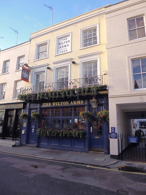
no 71 (Wilton Arms)
(Formerly listed as The Wilton Arms (no. 10))
II
Public house, 1825-6. Rendered brick, roof hidden behind parapet. Ground floor occupied by timber pub frontage, largely C20. Floor-plan two rooms deep, and three bays wide, three storeys high. Frontage a symmetrical composition, the upper floors with twelve-light glazing bar sashes in moulded architrave surrounds, save for the central second-floor window which is blind and inscribed 'THE WILTON ARMS 1826'. Balcony to first floor on heavy timber brackets with C20 ironwork. Pub frontage with doors to either side of small paned four-bay glazed front, with late C20 fascia and lamp. The interior retains some slender cast-iron columns and cornices, also an early or mid-C19 grate in late C20 surround.
Included as an unusual, dated example of a surviving 1820s public house. Most London pubs were rebuilt or dramatically elaborated in the 1890s.
Listing NGR: TQ2804179507
External links are from the relevant listing authority and, where applicable, Wikidata. Wikidata IDs may be related buildings as well as this specific building. If you want to add or update a link, you will need to do so by editing the Wikidata entry.


Other nearby listed buildings
