Approximate Location Map
Large Map »
Latitude: 52.2264 / 52°13'35"N
Longitude: -2.7347 / 2°44'4"W
OS Eastings: 349913
OS Northings: 258944
OS Grid: SO499589
Mapcode National: GBR FK.1VP6
Mapcode Global: VH84W.K94K
Plus Code: 9C4V67G8+H4
Entry Name: 75-85 Etnam Street (odd)
Listing Date: 9 July 1976
Last Amended: 3 March 2023
Grade: II
Source: Historic England
Source ID: 1255443
English Heritage Legacy ID: 459700
ID on this website: 101255443
Location: Leominster, County of Herefordshire, HR6
County: County of Herefordshire
Civil Parish: Leominster
Built-Up Area: Leominster
Traditional County: Herefordshire
Lieutenancy Area (Ceremonial County): Herefordshire
Church of England Parish: Leominster
Church of England Diocese: Hereford
Tagged with: Pub
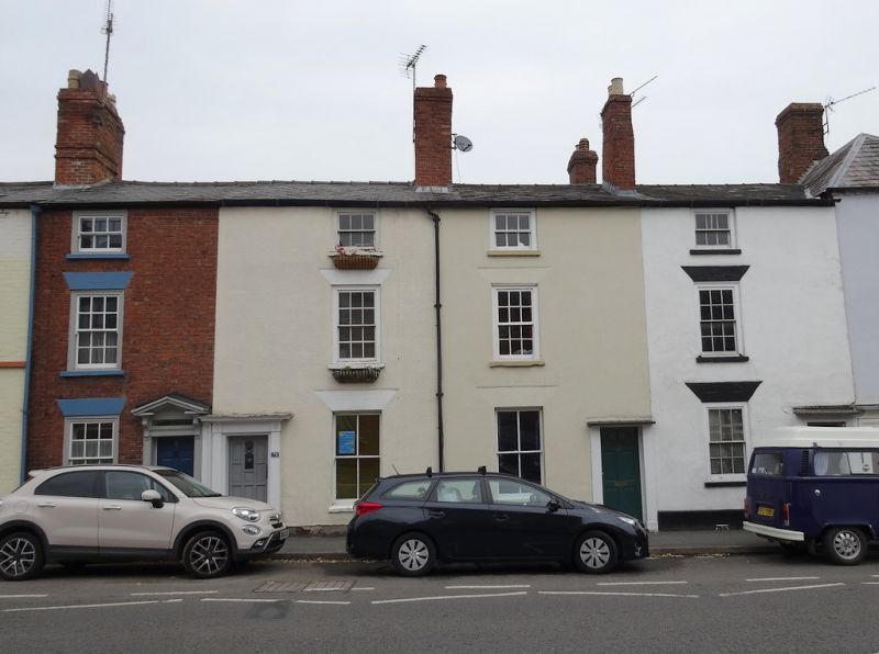
Terrace of five cottages and a former public house constructed in the late-C18 to early-C19, with minor alterations during the later-C19. Number 75 may have earlier origins, and was converted from a public house to a dwelling in the late-C20.
Terrace of five cottages and a former public house constructed in the late-C18 to early-C19, with minor alterations during the later-C19. Number 75 may have earlier origins, and was converted from a public house to a dwelling in the late-C20.
MATERIALS: the terrace is constructed of red brick with different finishes applied to the principal, south elevation of each cottage. Number 75 is of painted brickwork; Number 77 has exposed red brick in Flemish bond; and numbers 79-85 have roughcast rendering. The roof covering is natural slate except at number 79, which has composite tiles.
PLAN: numbers 77 to 85 are arranged on a rectangular, one-bay plan with two rooms upstairs and two rooms downstairs. Number 75 occupies a wider and longer plan, with two bays onto Etnam Street and a pitch-roofed range extending northward. Each property has been extended to the rear (north) to greater or lesser extents.
EXTERIOR: the terrace comprises six properties, five of which (numbers 77 to 85) are of a matching design, with number 75 being larger and formerly in use as a public house. The terrace has a continuous pitched roof from number 75 to number 83, with number 85 having a separate hipped roof and dentillated eaves, and being slightly taller than the rest of the terrace. The ridgeline is punctuated by three tall chimney stacks on the party walls between numbers 75 and 77, number 79 and 81, and numbers 81 to 83. Number 85 has a separate ridge stack rising from its hipped roof. There are three further chimney stacks to the rear extensions.
Number 75, at the western end of the terrace, has a corner entrance on Etnam Street with a modern (late-C20) door within a moulded frame with elaborate scroll brackets above. Immediately to the east of the door, on the Etnam Street elevation, is a glazed ceramic tile bearing the West Country Ales logo with the motto ‘BEST IN THE WEST’. To the east of the tile are two window openings with stucco cills and rendered, flat-arched heads, containing C20 timber casements. There are two windows each on the first and second floors, those on the first floor being larger, with rendered flat-arched heads and a unifying cill band. All four contain C20 timber casements matching those on the ground floor. The west elevation, onto Dukes Walk, is of three storeys stepping down to two. Within the three-storey, south range is a timber sash window with eight-over-eight glazing lighting a staircase from ground to first floor, and a small, C20 casement to the second floor. The uneven surface of the first floor of the two-storey north range may indicate timber framing within and therefore an earlier construction date. This range has a pitched roof and has a two-over-two glazed, timber sash window on the ground floor and an eight-over-eight glazed, timber sash window on the first floor. Both windows have rendered cills. Adjacent to the ground-floor window is a bricked-up doorway with a retained boot scraper. There is a further, single-storey, brick extension to the north, probably of the C20.
Numbers 77 to 85 are of largely matching design, consisting of a single-bay frontage with a single column of timber sash windows to each floor and an adjacent doorway on the ground floor – at numbers 77, 81 and 83, the doorway is to the east of the window and at numbers 79 and 85 the doorway is to the west. The ground- and first-floor windows to all five cottages have stucco cills and rendered, flat-arched heads, with those at numbers 79, 81 and 83 being rusticated. The glazing pattern varies slightly across the five cottages. Numbers 77, 79, 81 and 83 are largely matching, with six-over-six glazing to the ground and first floor and three-over-three glazing to the second floor, the exceptions being at numbers 79 and 81 where the ground-floor windows have two-over-two glazing. At number 85, the ground and first-floor windows are larger, with eight-over-eight glazing. Nearly all windows are set within moulded timber frames slightly recessed within the façade, again with the exception of the ground-floor windows at numbers 79 and 81, where the windows are more deeply recessed and have no visible surrounds. The doors and doorframes vary between each property. Number 77 has a six-panelled door beneath a plain, rectangular overlight, within a moulded timber doorcase with consoles and an open pediment hood. Number 79 has a C20, multi-panelled door set within a moulded timber doorcase with bosses to the header. Numbers 81 and 83 have late-C20 doors set within plain doorframes with simple, flat hoods. Number 85 has a C20, four-panelled door set within a reeded timber doorframe with a flat, lead hood.
Along with number 75, all five cottages appear to have been extended to the rear (north).
The town of Leominster traces its origins to the establishment of a religious house there during the C7 or earlier. The Saxon settlement endured repeated Viking raids and is recorded as a sizeable town in the Domesday Book (1086), with 27 households. In the early-C12, King Henry I established a Benedictine Priory in the town and granted a foundation charter for the town’s market. The town thrived throughout the later medieval period, despite periodic unrest due to its location in the border region. Leominster wool was prized across Europe and bestowed considerable wealth upon the town. The town centre retains many medieval and early-modern buildings; secular buildings are timber framed while surviving Priory buildings are constructed of local sandstone. The town centre retains an essentially medieval street pattern, with long, narrow burgage plots fronting the north-south spine road of Broad Street-High Street-South Street, and Corn Square (the historic market place) lying to the east of the High Street. The remains of the Priory, dissolved in 1539, lie to the north-east of the town centre. The town remained a prominent local centre into the C18 and C19. During this period, many timber-framed buildings were replaced (or refronted) by brick buildings with Classical elevations. Many houses in the town centre were partially converted to commercial use and equipped with shopfronts during the later-C19 and C20.
75-85 Etnam Street are a terrace of cottages constructed in the late-C18 or early-C19. Number 75, at the western end of the terrace, is considerably larger than the five other cottages and was possibly built as a public house. The uneven surface of the first-floor rendering, and the form of the pitch-roofed rear range, are suggestive of timber framing and may indicate an earlier construction date. The building was in use as a public house by 1885 and remained as such until the late-C20. The public house had a number of names including the Dukes Arms and Fatty's Public House. Number 85, at the eastern end of the terrace, is slightly wider than the other houses and has a slightly higher, hipped roof. Relatively modest, decorative alterations were made to the front (south) elevations of the houses throughout the C19 and C20. Various extensions and outbuildings had been added to the rear (north) of the terrace by 1885, and some of these appear to survive much-altered today.
External links are from the relevant listing authority and, where applicable, Wikidata. Wikidata IDs may be related buildings as well as this specific building. If you want to add or update a link, you will need to do so by editing the Wikidata entry.


Other nearby listed buildings
