Approximate Location Map
Large Map »
Latitude: 51.4423 / 51°26'32"N
Longitude: 0.7519 / 0°45'6"E
OS Eastings: 591345
OS Northings: 175068
OS Grid: TQ913750
Mapcode National: GBR RS1.JX5
Mapcode Global: VHKJ6.Z0CP
Plus Code: 9F32CQR2+WQ
Entry Name: Boundary Wall Extends from Main Gate Round South and East Sides of Former Dockyard
Listing Date: 15 March 1977
Last Amended: 13 August 1999
Grade: II
Source: Historic England
Source ID: 1259030
English Heritage Legacy ID: 446125
ID on this website: 101259030
Location: Blue Town, Swale, Kent, ME12
County: Kent
District: Swale
Electoral Ward/Division: Sheerness
Parish: Sheerness
Built-Up Area: Sheerness
Traditional County: Kent
Lieutenancy Area (Ceremonial County): Kent
Tagged with: Wall
TQ 9175 SW
933/2/116
15.03.1977
GARRISON ROAD
Sheerness Dockyard
Boundary wall extends from Main Gate round S and E sides of former Dockyard
GV
II
Includes: Boundary wall, extends from Main Gate round S and E sides of former Dockyard, HIGH STREET, SHEERNESS DOCKYARD
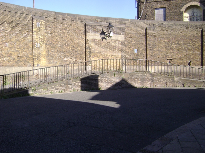
Dockyard boundary wall. 1824-31, by Sir John Rennie. Yellow stock brick with granite plinth and coping. Tall wall with a band of granite ashlar, above which shallow buttresses divide the wall into square panels. Extends approximately 500 metres SE from Nos 1 and 2 Main Gate to the N of the former Dockyard Church (qqv), from where a section ramps down to extend to meet the retaining wall in front of the Church. The main wall runs E of the Dockyard House garden (qv), where it contains a segmental- arched doorway leading from Church Road for officers going to church. The wall along the S side of the yard extends from the Wend of Naval Terrace (qv), and extends W for approx. 300m before turning S for approx. 170m; in the corner ramps lead up to an entrance.
This section of wall facing High Street has square lamps on cast-iron brackets attached at intervals. HISTORY: built by Rennie to enclose his complete rebuilding of the Sheerness yard in the 1820s. Of historic interest, and part of a good group with the officers' accommodation, church and offices (qqv) in the little-altered SE corner of the yard. (Sources: Coad J: The Royal Dockyards 1690-1850: Aldershot: 1989: 182; Rennie Sir J: The Formation and Construction of British and Foreign Harbours: London: 1851: 41).
TQ 9175 SW
933/2/116
HIGH STREET
Sheerness Dockyard
Boundary wall, extends from Main Gate round S and E sides of former Dockyard
GV
II
See under: Boundary wall extends from Main gate round S and E sides
of former Dockyard, GARRISON ROAD, SHEERNESS DOCKYARD
Listing NGR: TQ9134575068
External links are from the relevant listing authority and, where applicable, Wikidata. Wikidata IDs may be related buildings as well as this specific building. If you want to add or update a link, you will need to do so by editing the Wikidata entry.


Other nearby listed buildings
