Approximate Location Map
Large Map »
Latitude: 51.2772 / 51°16'37"N
Longitude: 1.0786 / 1°4'43"E
OS Eastings: 614816
OS Northings: 157614
OS Grid: TR148576
Mapcode National: GBR TY2.X32
Mapcode Global: VHLGM.N528
Plus Code: 9F3373GH+VF
Entry Name: 27, Watling Street
Listing Date: 3 May 1967
Grade: II
Source: Historic England
Source ID: 1259829
English Heritage Legacy ID: 443720
ID on this website: 101259829
Location: Canterbury, Kent, CT1
County: Kent
District: Canterbury
Electoral Ward/Division: Westgate
Parish: Non Civil Parish
Built-Up Area: Canterbury
Traditional County: Kent
Lieutenancy Area (Ceremonial County): Kent
Tagged with: Building
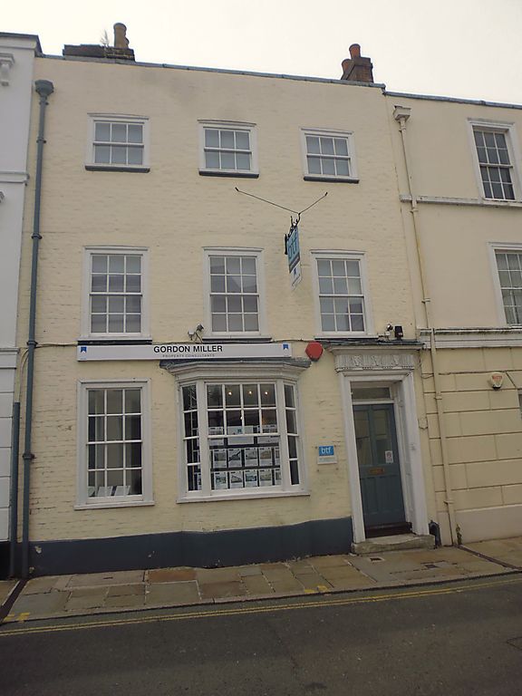
1.
944 WATLING STREET
(South West Side)
No 27
TR 1457 NE 4/222A 3.5.67.
II GV
2.
Mid C18. 3 storeys painted brick. Coping. Rainwater head. 3 sashes with
glazing bars iniact. Ground floor canted bay with modillioned cornice. Plinth.
Dcorcase has cornice with alternate triglyph and skull frieze. Moulded architrave.
Panelled reveals. Rectangular fanlight. 2 stone steps.
Nos 24 to 27 (consec) form a group.
Listing NGR: TR1481157612
External links are from the relevant listing authority and, where applicable, Wikidata. Wikidata IDs may be related buildings as well as this specific building. If you want to add or update a link, you will need to do so by editing the Wikidata entry.


Other nearby listed buildings
