Approximate Location Map
Large Map »
Latitude: 51.2781 / 51°16'41"N
Longitude: 1.0765 / 1°4'35"E
OS Eastings: 614663
OS Northings: 157710
OS Grid: TR146577
Mapcode National: GBR TY2.WGC
Mapcode Global: VHLGM.L4YK
Plus Code: 9F3373HG+6H
Entry Name: Stour Vill
Listing Date: 7 September 1973
Grade: II
Source: Historic England
Source ID: 1259904
English Heritage Legacy ID: 443438
ID on this website: 101259904
Location: Canterbury, Kent, CT1
County: Kent
District: Canterbury
Electoral Ward/Division: Westgate
Parish: Non Civil Parish
Built-Up Area: Canterbury
Traditional County: Kent
Lieutenancy Area (Ceremonial County): Kent
Tagged with: Architectural structure
1.
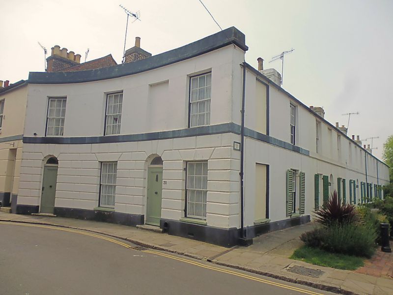
944 STOUR STREET
(North West Side)
Nos 1 to 5 (consec)
(Stour Vill).
No 30.
TR 1457 NE 4/708
II GV
2.
Early C19. 2 storeys stuccoed, Slate roof with 5 cement chimney stacks.
2 sashes with glazing bars intact and 1 blank to each house. Shutters to
ground floor sashes. Round-headed doorcases. No 30 has a curved front. A
Grade II group.
Listing NGR: TR1466957695
External links are from the relevant listing authority and, where applicable, Wikidata. Wikidata IDs may be related buildings as well as this specific building. If you want to add or update a link, you will need to do so by editing the Wikidata entry.


Other nearby listed buildings
