Approximate Location Map
Large Map »
Latitude: 51.2827 / 51°16'57"N
Longitude: 1.0781 / 1°4'41"E
OS Eastings: 614755
OS Northings: 158231
OS Grid: TR147582
Mapcode National: GBR TY2.HDS
Mapcode Global: VHLGM.M1T0
Plus Code: 9F3373MH+36
Entry Name: 16, Pound Lane
Listing Date: 3 December 1949
Grade: II
Source: Historic England
Source ID: 1260374
English Heritage Legacy ID: 440826
ID on this website: 101260374
Location: Canterbury, Kent, CT1
County: Kent
District: Canterbury
Electoral Ward/Division: Westgate
Parish: Non Civil Parish
Built-Up Area: Canterbury
Traditional County: Kent
Lieutenancy Area (Ceremonial County): Kent
Tagged with: Building
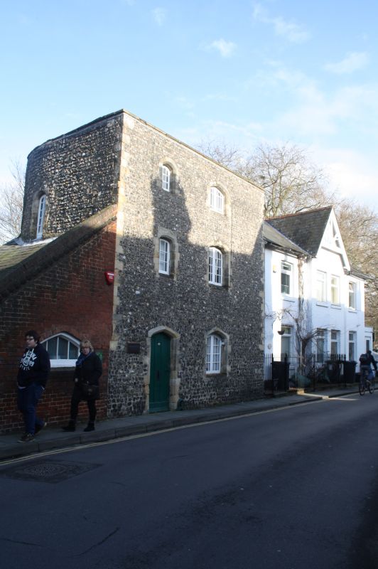
1.
944 POUND LANE
No 16
TR 1458 SE 2/99 3.12.49.
II
2.
A C14 tower of the City Walls, greatly restored. Semi-circular shaped, 3
storeys flint faced with stone quoins. Stone coping. 2 modern casements
have been inserted. Blocked slit windows, Pointed doorcase with wooden door.
Listing NGR: TR1475558233
External links are from the relevant listing authority and, where applicable, Wikidata. Wikidata IDs may be related buildings as well as this specific building. If you want to add or update a link, you will need to do so by editing the Wikidata entry.


Other nearby listed buildings
