Approximate Location Map
Large Map »
Latitude: 51.2783 / 51°16'41"N
Longitude: 1.081 / 1°4'51"E
OS Eastings: 614974
OS Northings: 157751
OS Grid: TR149577
Mapcode National: GBR TY2.XSM
Mapcode Global: VHLGM.P4BC
Plus Code: 9F3373HJ+89
Entry Name: 13, the Parade
Listing Date: 7 September 1973
Grade: II
Source: Historic England
Source ID: 1260381
English Heritage Legacy ID: 440821
ID on this website: 101260381
Location: Canterbury, Kent, CT1
County: Kent
District: Canterbury
Electoral Ward/Division: Westgate
Parish: Non Civil Parish
Built-Up Area: Canterbury
Traditional County: Kent
Lieutenancy Area (Ceremonial County): Kent
Tagged with: Building
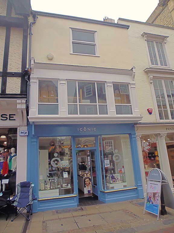
1.
944 THE PARADE
(South West Side)
No 13
TR 1457 NE 4/61A
II GV
2.
Mediaeval interior refaced in C18. 3 storeys stuccoed. Renewed tiled roof.
1 sash without glazing barn, 1st floor C19 3 light window now obscured by
fascia.
Nos 12 & 13 form a group.
Listing NGR: TR1497257748
External links are from the relevant listing authority and, where applicable, Wikidata. Wikidata IDs may be related buildings as well as this specific building. If you want to add or update a link, you will need to do so by editing the Wikidata entry.


Other nearby listed buildings
