Approximate Location Map
Large Map »
Latitude: 51.2787 / 51°16'43"N
Longitude: 1.0803 / 1°4'49"E
OS Eastings: 614925
OS Northings: 157788
OS Grid: TR149577
Mapcode National: GBR TY2.PYL
Mapcode Global: VHLGM.N4Z3
Plus Code: 9F3373HJ+F4
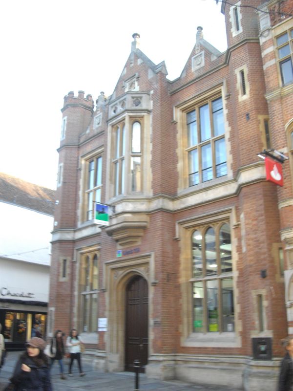
Entry Name: Lloyd's Bank
Listing Date: 7 September 1973
Grade: II
Source: Historic England
Source ID: 1260826
English Heritage Legacy ID: 439374
ID on this website: 101260826
Location: Canterbury, Kent, CT1
County: Kent
District: Canterbury
Electoral Ward/Division: Westgate
Parish: Non Civil Parish
Built-Up Area: Canterbury
Traditional County: Kent
Lieutenancy Area (Ceremonial County): Kent
Tagged with: Bank building
1.
944 HIGH STREET
(South West Side)
TR 1457 NE 4/515 No 49 (Lloyd's Bank)
II GV
2.
Later C19. 2 storeys brick with stone dressings. Crenellated parapets.
2 8 sided corner turrets. Mullioned and transomed windows With hood moulding.
Stone stringcourse. 1st floor oriel. Central doorcase with hood moulding.
4 centre arched door and quatrefoil ornament in spandrels.
Nos 37 to 46 (consec), Nos 48& 49 form a group.
Listing NGR: TR1491257778
External links are from the relevant listing authority and, where applicable, Wikidata. Wikidata IDs may be related buildings as well as this specific building. If you want to add or update a link, you will need to do so by editing the Wikidata entry.


Other nearby listed buildings
