Approximate Location Map
Large Map »
Latitude: 54.6863 / 54°41'10"N
Longitude: -1.206 / 1°12'21"W
OS Eastings: 451283
OS Northings: 532653
OS Grid: NZ512326
Mapcode National: GBR NG07.PV
Mapcode Global: WHD6F.FGYR
Plus Code: 9C6WMQPV+GH
Entry Name: Athenaeum the Athenaeum
Listing Date: 17 December 1985
Grade: II
Source: Historic England
Source ID: 1263433
English Heritage Legacy ID: 432347
ID on this website: 101263433
Location: Old Town, Hartlepool, County Durham, TS24
County: Hartlepool
Electoral Ward/Division: Headland and Harbour
Parish: Non Civil Parish
Built-Up Area: Hartlepool
Traditional County: Durham
Lieutenancy Area (Ceremonial County): County Durham
Church of England Parish: Stranton
Church of England Diocese: Durham
Tagged with: Architectural structure
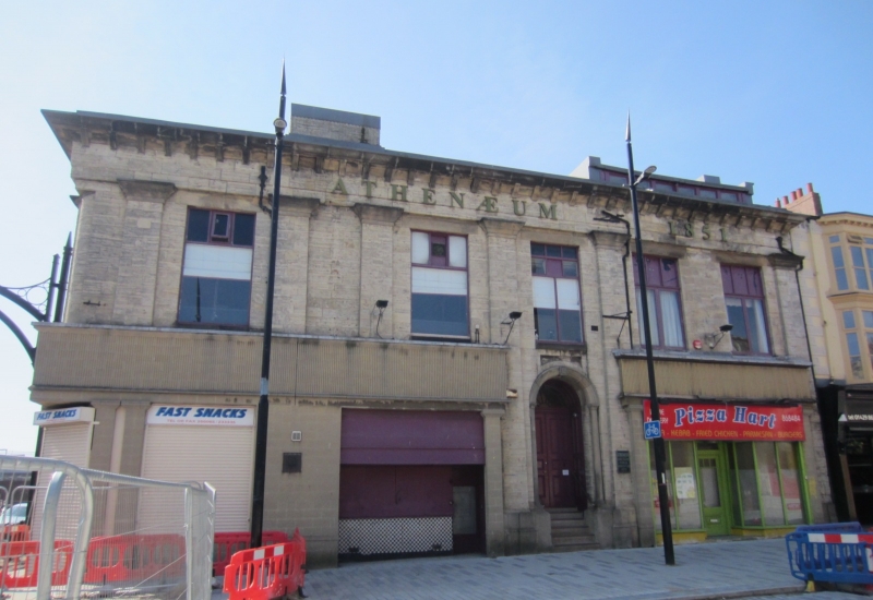
HARTLEPOOL CHURCH STREET
NZ 5132
(south side)
11/52 Nos. 17, 18 and 19
(The Athenaeum)
GV II
Literary and Mechanics' Institute, now a private club on first floor and
shop units below. 1851 on plaque to right of doorway, by R.H. Robson (Land
Agent to West Hartlepool Dock Co.). Limestone ashlar with sandstone
dressings; hipped mid C20 concrete tiled roof and 3 truncated stacks.
Plain classical style. 2 storeys and basement; occupying corner site.
Principal front to Church Street, of 5 bays defined by quasi Tuscan
pilasters : obscured on ground floor by late C19 to mid C20 shop fronts,
except for doorway to 4th bay having moulded round arch on engaged
quasi Tuscan columns, deeply recessed 6-panelled double doors, fanlight with
glazing bars, and panelled reveals. 2nd bay is narrower and blank, 5th is
wider having 2 windows. All windows are altered within original openings.
Frieze, modillion cornice and shallow parapet. Late C19 flat-roofed full
dormer above 5th bay. Left return (facing Lynn Street) of 8 symmetrical
bays in similar manner to front. Ground floor largely disused at time of
survey.
Listing NGR: NZ5128332653
External links are from the relevant listing authority and, where applicable, Wikidata. Wikidata IDs may be related buildings as well as this specific building. If you want to add or update a link, you will need to do so by editing the Wikidata entry.


Other nearby listed buildings
