Approximate Location Map
Large Map »
Latitude: 51.1351 / 51°8'6"N
Longitude: 0.2605 / 0°15'37"E
OS Eastings: 558251
OS Northings: 139747
OS Grid: TQ582397
Mapcode National: GBR MPS.LPW
Mapcode Global: VHHQD.GQLP
Plus Code: 9F3247P6+36
Entry Name: 24, MOUNT EPHRAIM ROAD (See details for further address information)
Listing Date: 20 May 1952
Grade: II
Source: Historic England
Source ID: 1266184
English Heritage Legacy ID: 168096
ID on this website: 101266184
Location: Royal Tunbridge Wells, Tunbridge Wells, Kent, TN1
County: Kent
District: Tunbridge Wells
Electoral Ward/Division: Culverden
Parish: Non Civil Parish
Built-Up Area: Royal Tunbridge Wells
Traditional County: Kent
Lieutenancy Area (Ceremonial County): Kent
Church of England Parish: Tunbridge Wells St John
Church of England Diocese: Rochester
Tagged with: Building
MOUNT EPHRAIM ROAD
1.
1746
(North Side)
No 24
TQ 5839 NW 3/55 20.5.52.
II GV
2.
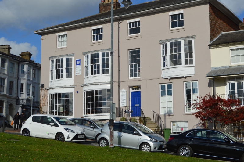
Including No 45 Mount Ephraim.
A rather large early C19 house. 3 storeys and semi-basement stuccoed. Eaves
cornice. 4 windows facing south, 1 window and 1 blocked window space facing
west. The iron balcony on the 1st floor with hood has recently been removed.
3 large curved windows of 3 lights each on this floor and 2 on the ground floor.
The ground floor windows have heavy hoods covering the whole of the top half of
the windows but the hoods have been removed from the 1st floor windows. Doorcase
with curved flight of steps leading up to it and iron railing fronting the platform.
Rectangular fanlight and 5 panel moulded door. Porch on the west front with fluted
columns and C19 shop front.
Nos 18 to 24 (even) form a group.
Listing NGR: TQ5825239752
External links are from the relevant listing authority and, where applicable, Wikidata. Wikidata IDs may be related buildings as well as this specific building. If you want to add or update a link, you will need to do so by editing the Wikidata entry.


Other nearby listed buildings
