Approximate Location Map
Large Map »
Latitude: 51.4731 / 51°28'23"N
Longitude: -2.7734 / 2°46'24"W
OS Eastings: 346379
OS Northings: 175188
OS Grid: ST463751
Mapcode National: GBR JH.LF2F
Mapcode Global: VH7C2.W75K
Plus Code: 9C3VF6FG+6J
Entry Name: Entrance Lodge, Walls, Piers, Gates and Railings at Portishead Burial Ground
Listing Date: 22 April 1994
Grade: II
Source: Historic England
Source ID: 1270255
English Heritage Legacy ID: 459873
ID on this website: 101270255
ST 47 NE PORTISHEAD CLEVEDON ROAD
(south side)
2/93 Entrance lodge, walls, piers,
gates and railings at
Portishead Burial
Ground
II
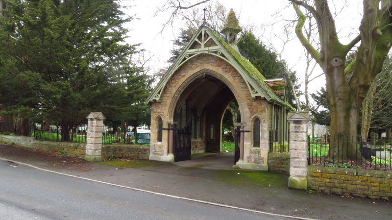
Entrance lodge, walls, piers, gates and railings. Mid Zig. Snecked limestone
rubble with stone dressings, lodge has plain and fish-scale tiled roof with
wrought iron crestings and finials to gables; limestone piers and cast iron
railings and gates. Open lodge has front gable end with high pointed arched
opening, roll-moulded, polished granite jamb-shafts with composite capitals,
lancet to each side, bargeboards, gates with twisted uprights and spear finials.
Left and right return glazed, 5 lights each, central one taller, trefoil-headed
with small gable above; rear as front, without jamb shafts or gates, plainer
mouldings. Limestone plinth and quoins, bellcote set diagonally on roof ridge
with louvres and bellcast shape roof. Wall attached to each side of lodge,
swept round to square pier, about 3 metres high, in vermiculated ashlar with
triangular shaped top; wall about 1/2 metre high, extends about 80 metres to east,
stepped to accommodate slope of ground, plain railings, principals with curved
struts and knob finials, at east end a pair of similar gate piers, small gate
with knob finials to uprights and horizontal strut; wall and railings extend
about 90 metres to south west to similar terminal pier. South west and east
boundaries of burial ground have plain railings only.
Listing NGR: ST4637975188
External links are from the relevant listing authority and, where applicable, Wikidata. Wikidata IDs may be related buildings as well as this specific building. If you want to add or update a link, you will need to do so by editing the Wikidata entry.


Other nearby listed buildings
