Approximate Location Map
Large Map »
Latitude: 52.2263 / 52°13'34"N
Longitude: -2.7391 / 2°44'20"W
OS Eastings: 349612
OS Northings: 258939
OS Grid: SO496589
Mapcode National: GBR FK.1TD5
Mapcode Global: VH84W.G9TM
Plus Code: 9C4V67G6+G9
Entry Name: 8 South Street
Listing Date: 9 July 1976
Last Amended: 3 October 2023
Grade: II
Source: Historic England
Source ID: 1270287
English Heritage Legacy ID: 459772
ID on this website: 101270287
Location: Leominster, County of Herefordshire, HR6
County: County of Herefordshire
Civil Parish: Leominster
Built-Up Area: Leominster
Traditional County: Herefordshire
Lieutenancy Area (Ceremonial County): Herefordshire
Church of England Parish: Leominster
Church of England Diocese: Hereford
Tagged with: Building
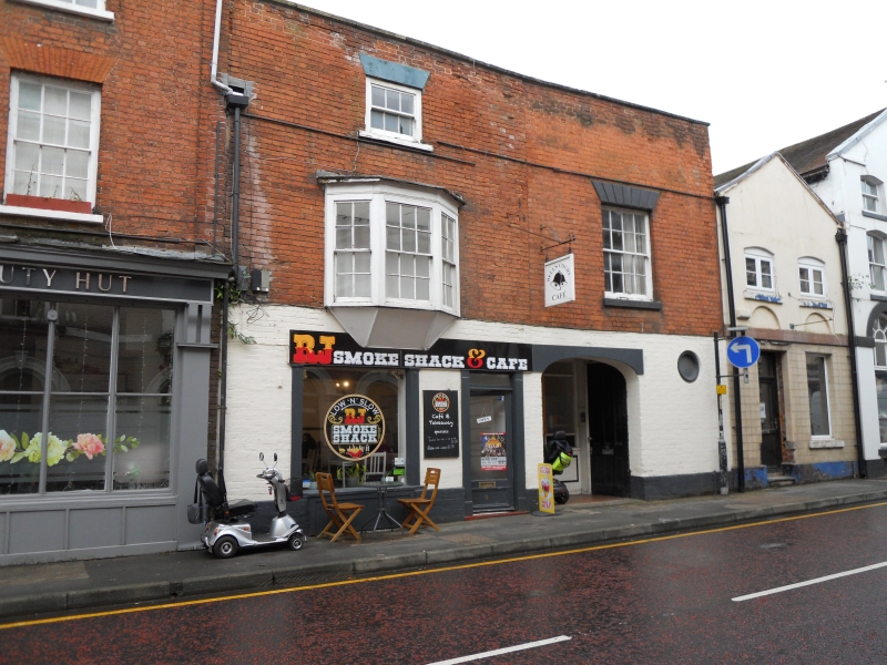
House, probably built in the C17, extended and refronted during the late-C18 or C19.
House, probably built in the C17, extended and refronted during the late-C18 or C19.
MATERIALS: the southern half of the South Street range has a timber-framed structure at its core. The front (east) elevation is constructed of red brick laid in Flemish bond and painted on the ground floor. The ground-floor shop fronts are of timber and glass.
PLAN: the building is arranged in three ranges on an L-shaped plan, with the principal, east section fronting South Street composed of a north and south range and a third, ancillary range extending westwards along the southern plot boundary.
EXTERIOR: the building is of two to three storeys plus basement, across two wide bays onto South Street to the east. The east elevation is arranged in two sections. The southern section has three full storeys plus basement. On the ground floor, there is a plate-glass shop window with timber pilasters and cill, and to the north, a glazed door with matching pilasters and a plain over light. A plain, timber fascia board runs over the shop window and door. Beneath the shop window is a C21 timber cover to a basement light. On the first floor, there is a canted oriel window, the angled under side of which cuts into the fascia board below. The oriel has three timber sash windows, the central sash having six-over-six glazing, the outer sashes having four-over-four glazing. On the second floor is a timber sash window with three-over-three glazing, slightly recessed into the brickwork and with a rendered, flat-arched head. Above, a stone-coped brick parapet conceals the roof from the street.
The northern half is of two storeys, with a tall, brick parapet to match the height of the southern half of the façade. On the ground floor offset to the south is a shallow, segmental arched opening, formerly a carriage entrance. Recessed within the archway is a shop front with timber stall risers, pilasters and fixed, tripartite glazing, flanked by a pair of six-panelled doors formerly belonging to the carriage entrance. The southern door is now fixed back while the northern door appears to serve as the entrance to the dwelling above. To the north of the recess is a bullseye window with a casement window. On the first floor is a timber sash window with six-over-six glazing and horns, recessed into the façade, with a rendered cill and a rusticated stucco flat-arched head. The window is set somewhat higher than the oriel window to the south suggesting different floor levels between the north and southern halves of the building. To the rear are a series of C19 and C20 extensions.
The town of Leominster traces its origins to the establishment of a religious house there during the C7 or earlier. The Saxon settlement endured repeated Viking raids and is recorded as a sizeable town in the Domesday Book (1086), with 27 households. In the early-C12, King Henry I established a Benedictine Priory in the town and granted a foundation charter for the town’s market. The town thrived throughout the later medieval period, despite periodic unrest due to its location in the border region. Leominster wool was prized across Europe and bestowed considerable wealth upon the town. The town centre retains many medieval and early-modern buildings; secular buildings are timber framed while surviving Priory buildings are constructed of local sandstone. The town centre retains an essentially medieval street pattern, with long, narrow burgage plots fronting the north-south spine road of Broad Street-High Street-South Street, and Corn Square (the historic market place) lying to the east of the High Street. The remains of the Priory, dissolved in 1539, lie to the north-east of the town centre. The town remained a prominent local centre into the C18 and C19. During this period, many timber-framed buildings replaced (or refronted) by brick buildings with Classical elevations. Many houses in the town centre were partially converted to commercial use and equipped with shopfronts during the later C19 and C20.
8 South Street appears to be a C17 timber-framed building that was extended and refronted during the late-C18 or early-C19. There is timber framing within the café occupying the southern half of the South Street frontage. This frontage, the building’s principal elevation, was constructed in two phases as indicated by a distinct joint in the brickwork down the centre of the façade. By 1885, the building was a public house named The Ring of Bells. The shallow-arched opening to the ground floor, previously a carriage entrance, offers evidence that the building was in use as a public house or inn from the time of its refronting. The canted, first-floor oriel window was added during the C19. The building appears to have been converted to a shop during the early to mid-C20, with the carriage entrance filled in and a shopfront inserted. The ground floor of the building is currently (2022) subdivided into two commercial units. The upper floors appear to be in residential use.
External links are from the relevant listing authority and, where applicable, Wikidata. Wikidata IDs may be related buildings as well as this specific building. If you want to add or update a link, you will need to do so by editing the Wikidata entry.


Other nearby listed buildings
