Approximate Location Map
Large Map »
Latitude: 51.8605 / 51°51'37"N
Longitude: -2.2585 / 2°15'30"W
OS Eastings: 382297
OS Northings: 218026
OS Grid: SO822180
Mapcode National: GBR 0JT.CTW
Mapcode Global: VH94B.SHXK
Plus Code: 9C3VVP6R+6J
Entry Name: Llanthony Priory, Remains of Outer Gatehouse
Listing Date: 23 January 1952
Last Amended: 15 December 1998
Grade: I
Source: Historic England
Source ID: 1271694
English Heritage Legacy ID: 472288
ID on this website: 101271694
Location: High Orchard, Gloucester, Gloucestershire, GL2
County: Gloucestershire
District: Gloucester
Electoral Ward/Division: Westgate
Parish: Non Civil Parish
Built-Up Area: Gloucester
Traditional County: Gloucestershire
Lieutenancy Area (Ceremonial County): Gloucestershire
Church of England Parish: Hempsted with Gloucester, Saint Mary de Lode and Saint Mary de Crypt
Church of England Diocese: Gloucester
Tagged with: Gatehouse
GLOUCESTER
SO81NW LLANTHONY ROAD
844-1/3/157 (East side)
23/01/52 Llanthony Priory, Remains of Outer
Gatehouse
(Formerly Listed as:
HEMPSTED LANE
Remains of Llanthony Priory)
GV I
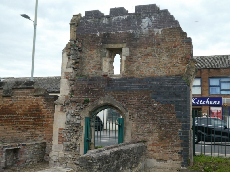
The ruined remains of the outer gatehouse to the outer court
of the former Augustinian Priory of Llanthony Secunda.
1494-1500. For Henry Dene, Prior, and Bishop of Bangor. Part
of Ancient Monument in the care of Gloucester City Council.
Demolished portions excavated 1975. Cotswold stone ashlar
facing on red brick.
PLAN: originally a rectangular structure with carriage way on
the left hand (north) side and pedestrian entry on the right
hand (south) side; The southern half of the front wall extant
to full height, the other walls excavated and marked out at
ground level.
EXTERIOR: the front facing the road originally of two bays
defined by three buttresses; moulded crowning cornice and
crenellated parapet with weathered copings; the surviving
central and southern buttresses with weathered offsets; the
central buttress rises to the underside of the cornice, the
right hand buttress is capped by a cusped gablet; to the left
of the central buttress the surviving right-hand jamb and the
haunch of the carriage entrance archway with a double chamfer
and eared hoodmould; in the right hand bay the smaller
pedestrian doorway with four-centred, double chamfered arch
and eared hoodmould; at first-floor level above the pedestrian
entry a single-light arched window, formerly cinquefoiled,
with a rectangular, eared hoodmould, which lit former chamber
for the gatekeeper; set into the upper part of the wall face
three coats of arms carved in relief: the shield to the right
of the window with the arms of the prior, Henry Dene, the
shield to the left with the arms of the Bohuns, patrons of the
priory from 1175 to 1373, and the shield immediately above,
now defaced, with the arms of France and England quarterly for
King Henry VII.
Listing NGR: SO8229718025
External links are from the relevant listing authority and, where applicable, Wikidata. Wikidata IDs may be related buildings as well as this specific building. If you want to add or update a link, you will need to do so by editing the Wikidata entry.


Other nearby listed buildings
