Approximate Location Map
Large Map »
Latitude: 51.0661 / 51°3'57"N
Longitude: -1.7933 / 1°47'35"W
OS Eastings: 414578
OS Northings: 129661
OS Grid: SU145296
Mapcode National: GBR 51F.3FN
Mapcode Global: FRA 7649.F67
Plus Code: 9C3W3684+CM
Entry Name: The Chapter House
Listing Date: 28 February 1952
Grade: I
Source: Historic England
Source ID: 1273159
English Heritage Legacy ID: 446100
Also known as: King's Arms
The King's Arms Hotel
9 St John' s Street
ID on this website: 101273159
Location: The Friary, Wiltshire, SP1
County: Wiltshire
Civil Parish: Salisbury
Built-Up Area: Salisbury
Traditional County: Wiltshire
Lieutenancy Area (Ceremonial County): Wiltshire
Church of England Parish: Salisbury St Thomas and St Edmund
Church of England Diocese: Salisbury
Tagged with: Pub
This list entry was subject to a Minor Amendment on 6 September 2021 to update the name and address and to reformat the text to current standards
SU 1429 NE
4/133
ST JOHN'S STREET (East Side)
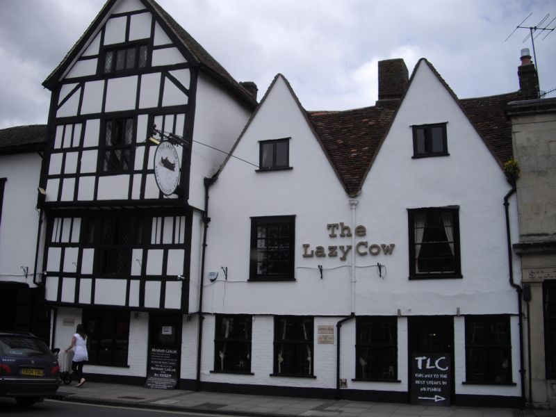
No 9 (The Chapter House)
(Formerly listed as No 9 (King's Arms))
28.2.52.
GV
C15-15. Four storey. A tall single gabled front of timber frame with wattle and daub infilling, oversailing at first and second floor levels, with moulded trimmers under each oversail and curved brackets under second floor. Moulded bargeboards to gable. Old tile roof. One four-light mullioned casement on third floor. Two three-light flanking central six-light mullioned and transomed casements on second floor. The outer windows now blocked. Similar arrangement on first floor with narrow lights flanking central window. All casements modern leaded, but frames original except to central windows, which have been restored. Modern casement and plain door on ground floor. Gabled three-storey extension right hand timber frame plastered. One C18 sash window on first floor and two modern casements on ground floor.
This Inn used for meetings of Royalists during Civil War in connection with flight of Charles II, and possible rescue of Charles I.
Interior: on the 1st floor panelling and original stone fireplace.
Nos 1 to 13 (odd) form a very important group.
Listing NGR: SU1458329657
External links are from the relevant listing authority and, where applicable, Wikidata. Wikidata IDs may be related buildings as well as this specific building. If you want to add or update a link, you will need to do so by editing the Wikidata entry.


Other nearby listed buildings
