Approximate Location Map
Large Map »
Latitude: 51.28 / 51°16'48"N
Longitude: 1.079 / 1°4'44"E
OS Eastings: 614829
OS Northings: 157934
OS Grid: TR148579
Mapcode National: GBR TY2.PM7
Mapcode Global: VHLGM.N392
Plus Code: 9F3373JH+2J
Entry Name: Two K6 Telephone Kiosks
Listing Date: 1 March 1989
Grade: II
Source: Historic England
Source ID: 1273439
English Heritage Legacy ID: 444969
ID on this website: 101273439
Location: Canterbury, Kent, CT1
County: Kent
District: Canterbury
Electoral Ward/Division: Westgate
Parish: Non Civil Parish
Built-Up Area: Canterbury
Traditional County: Kent
Lieutenancy Area (Ceremonial County): Kent
Tagged with: K6 telephone box
This List entry was subject to a Minor amendment on 18/03/2014
TR 1457 NE
4/779
CANTERBURY
BEST LANE
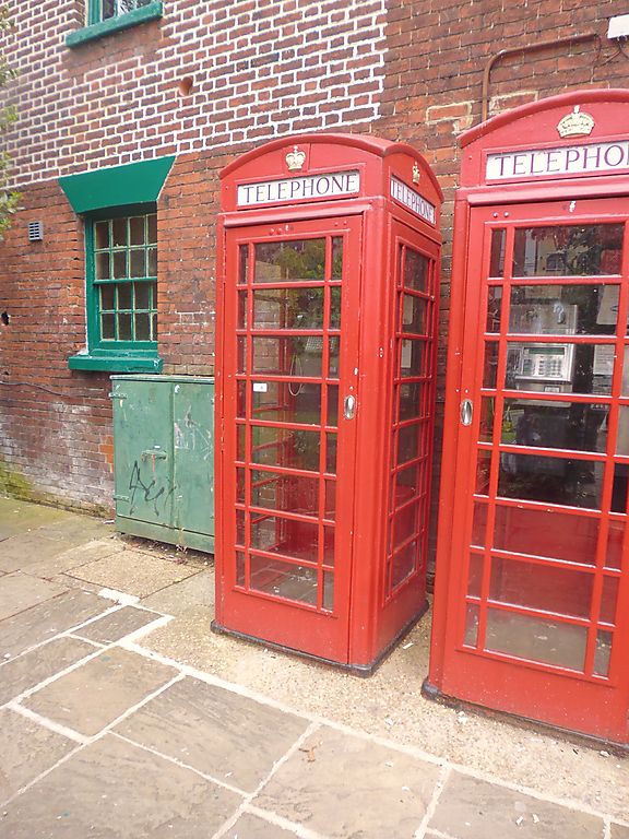
Two K6 Telephone Kiosks
GV
II
Telephone kiosks Type K6. Designed 1935 by Sir Giles Gilbert Scott. Made by
various contractors. Cast iron. Square kiosks with domed roof. Unperforated
crowns to top panels and margin glazing to windows and door.
Listing NGR: TR1482957934
External links are from the relevant listing authority and, where applicable, Wikidata. Wikidata IDs may be related buildings as well as this specific building. If you want to add or update a link, you will need to do so by editing the Wikidata entry.


Other nearby listed buildings
