Approximate Location Map
Large Map »
Latitude: 50.7251 / 50°43'30"N
Longitude: -3.5368 / 3°32'12"W
OS Eastings: 291625
OS Northings: 92842
OS Grid: SX916928
Mapcode National: GBR P0.PY1L
Mapcode Global: FRA 37G5.CY0
Plus Code: 9C2RPFG7+27
Entry Name: 39, Lower North Street
Listing Date: 18 June 1974
Grade: II
Source: Historic England
Source ID: 1273763
English Heritage Legacy ID: 417231
ID on this website: 101273763
Location: Exeter, Devon, EX4
County: Devon
District: Exeter
Electoral Ward/Division: St David's
Parish: Non Civil Parish
Built-Up Area: Exeter
Traditional County: Devon
Lieutenancy Area (Ceremonial County): Devon
Church of England Parish: Exeter St David
Church of England Diocese: Exeter
Tagged with: Building
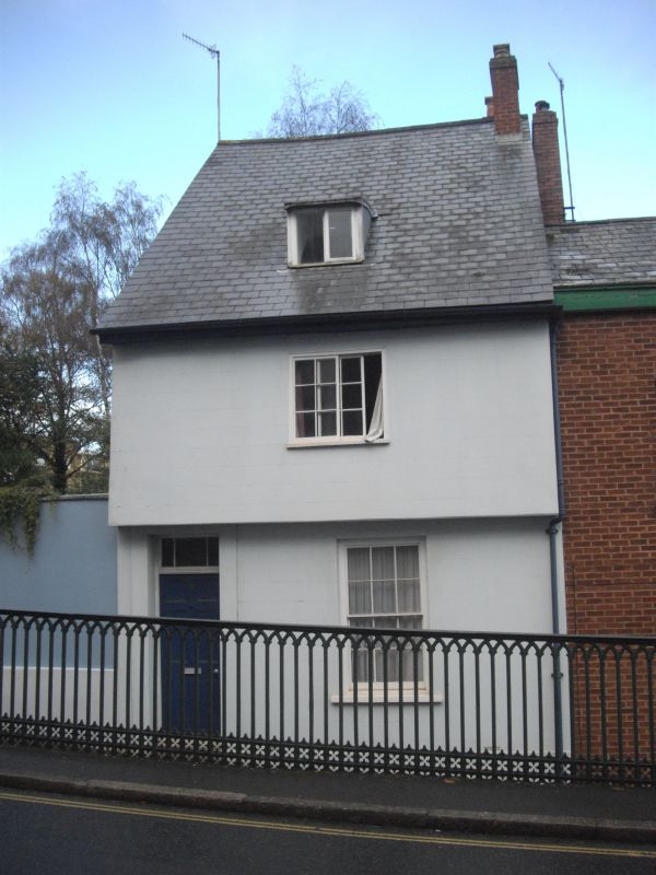
LOWER NORTH STREET
1.
1092
No 39
SX 9192 NE 2/349C
II GV
2.
C18. Timber framed with overhanging plaster front. Two storeys, on window. One
sash, one casement, one dormer. Slate roof.
All the listed buildin+s of Lower North Street form a group.
Nos 28 to 39 (consec) Lower North Street also form a group with No 2 St Davids Hill.
Listing NGR: SX9162592842
External links are from the relevant listing authority and, where applicable, Wikidata. Wikidata IDs may be related buildings as well as this specific building. If you want to add or update a link, you will need to do so by editing the Wikidata entry.


Other nearby listed buildings
