Approximate Location Map
Large Map »
Latitude: 50.7137 / 50°42'49"N
Longitude: -1.99 / 1°59'24"W
OS Eastings: 400800
OS Northings: 90451
OS Grid: SZ008904
Mapcode National: GBR XPW.QR
Mapcode Global: FRA 67Q6.2KF
Plus Code: 9C2WP275+FX
Entry Name: 6, St James's Close
Listing Date: 14 June 1954
Grade: II
Source: Historic England
Source ID: 1275393
English Heritage Legacy ID: 412585
ID on this website: 101275393
Location: Old Town, Bournemouth, Christchurch and Poole, Dorset, BH15
County: Bournemouth, Christchurch and Poole
Parish: Non Civil Parish
Built-Up Area: Poole
Traditional County: Dorset
Lieutenancy Area (Ceremonial County): Dorset
Church of England Parish: Poole St James with St Paul
Church of England Diocese: Salisbury
Tagged with: Building
POOLE
SZ0090SE ST JAMES'S CLOSE
958-1/17/151 (West side)
14/06/54 No.6
GV II
Formerly known as: No.6 WEST STREET.
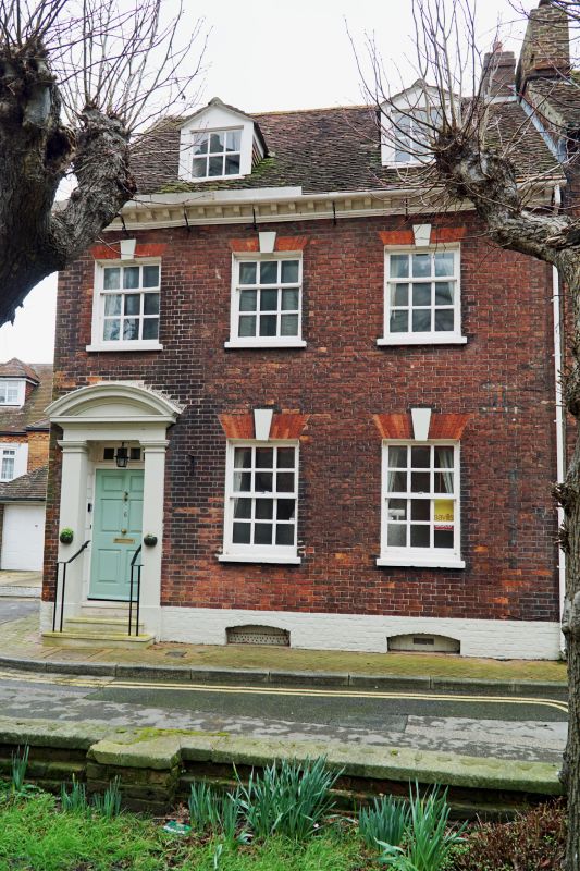
House. Mid C18. Flemish bond brickwork with painted stone
dressings, gauged brick arches, brick gable stack and a
pantile roof. Single-depth plan with rear outshut. 2 storeys,
basement and attic; 3-window range. Painted plinth and
bracketed eaves cornice, left-hand doorway has pilasters to a
segmental-arched pediment, recessed 3-light overlight and
6-panel door. Gauged brick flat keyed arches over 6/6-pane and
3/6-pane sashes with thick bars, and 2 mid C20 gabled dormers.
2 cambered-arched basement openings. INTERIOR not inspected
but reported to contain good original features.
(RCHME: County of Dorset (South East): London: 1970-: 236).
Listing NGR: SZ0080090451
External links are from the relevant listing authority and, where applicable, Wikidata. Wikidata IDs may be related buildings as well as this specific building. If you want to add or update a link, you will need to do so by editing the Wikidata entry.


Other nearby listed buildings
