Approximate Location Map
Large Map »
Latitude: 50.7825 / 50°46'57"N
Longitude: -1.1438 / 1°8'37"W
OS Eastings: 460456
OS Northings: 98457
OS Grid: SZ604984
Mapcode National: GBR 9BW.ZK7
Mapcode Global: FRA 87H0.N7M
Plus Code: 9C2WQVM4+2F
Entry Name: Boundary Wall of Graveyard of Former Church of St Mark
Listing Date: 20 April 1983
Grade: II
Source: Historic England
Source ID: 1276302
English Heritage Legacy ID: 409726
ID on this website: 101276302
Location: Alverstoke, Gosport, Hampshire, PO12
County: Hampshire
District: Gosport
Electoral Ward/Division: Anglesey
Parish: Non Civil Parish
Built-Up Area: Gosport
Traditional County: Hampshire
Lieutenancy Area (Ceremonial County): Hampshire
Church of England Parish: Alverstoke St Mary
Church of England Diocese: Portsmouth
Tagged with: Wall
ST MARKS ROAD
1.
5252
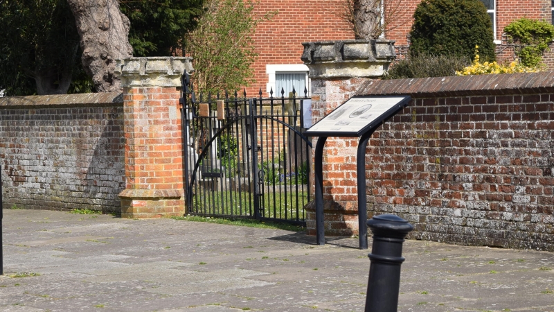
Boundary wall of graveyard
of former Church of St Mark
SZ 6098 SW 9/102
SZ 6098 SE 9/102
II
2.
Boundary wall in red brick. Flemish bond, with plinth; octagonal piers at entrance
and corner have sand-stone 'crenellated' caps.
Listing NGR: SZ6045098594
External links are from the relevant listing authority and, where applicable, Wikidata. Wikidata IDs may be related buildings as well as this specific building. If you want to add or update a link, you will need to do so by editing the Wikidata entry.


Other nearby listed buildings
