Approximate Location Map
Large Map »
Latitude: 52.6304 / 52°37'49"N
Longitude: 1.3063 / 1°18'22"E
OS Eastings: 623845
OS Northings: 308755
OS Grid: TG238087
Mapcode National: GBR WBZ.SM
Mapcode Global: WHMTN.149T
Plus Code: 9F43J8J4+4G
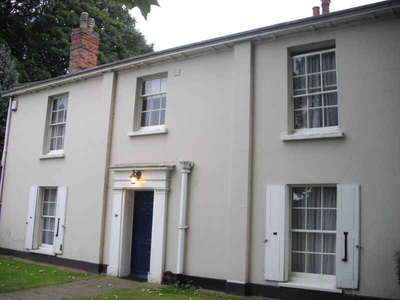
Entry Name: 24, the Close
Listing Date: 5 June 1972
Grade: II
Source: Historic England
Source ID: 1280256
English Heritage Legacy ID: 228940
ID on this website: 101280256
Location: Thorpe Hamlet, Norwich, Norfolk, NR1
County: Norfolk
District: Norwich
Electoral Ward/Division: Thorpe Hamlet
Parish: Non Civil Parish
Built-Up Area: Norwich
Traditional County: Norfolk
Lieutenancy Area (Ceremonial County): Norfolk
Tagged with: Building
TG 2308 NE THE CLOSE
17/191
5.6.72 No. 24
GV II
House. Circa 1840: Stuccoed with slate roof. 2 storeys. 3 wide bays.
Central door with flat pilasters and wide architrave having central
guttae bands and flat hood. Sash windows throughout in simple reveal with
glazing bars apart from ground floor right-hand window. Shutters on ground
floor windows. Paired modillion cornice.
Listing NGR: TG2384508755
External links are from the relevant listing authority and, where applicable, Wikidata. Wikidata IDs may be related buildings as well as this specific building. If you want to add or update a link, you will need to do so by editing the Wikidata entry.


Other nearby listed buildings
