Approximate Location Map
Large Map »
Latitude: 52.3355 / 52°20'7"N
Longitude: 0.8065 / 0°48'23"E
OS Eastings: 591309
OS Northings: 274534
OS Grid: TL913745
Mapcode National: GBR RF9.DRY
Mapcode Global: VHKCS.XKRG
Plus Code: 9F428RP4+6J
Entry Name: Old Maltsters Cottage
Listing Date: 14 July 1955
Last Amended: 1 February 1984
Grade: II
Source: Historic England
Source ID: 1284738
English Heritage Legacy ID: 284053
ID on this website: 101284738
Location: Honington, West Suffolk, IP31
County: Suffolk
District: West Suffolk
Civil Parish: Honington
Built-Up Area: Honington
Traditional County: Suffolk
Lieutenancy Area (Ceremonial County): Suffolk
Church of England Parish: Honington All Saints
Church of England Diocese: St.Edmundsbury and Ipswich
Tagged with: Cottage
This list entry was subject to a Minor Amendment on 20 September 2021 to remove superfluous amendment details, update the name and address and to reformat the text to current standards
TL 97 SW
3/76
HONINGTON
MALTING ROW (SOUTH SIDE)
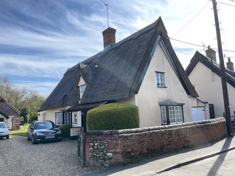
Old Maltsters Cottage
(Formerly listed as Old Master's Cottage, previously listed as Cottage immediately East of malting Row)
14.7.55
GV
II
House. Mid C17. One and a half storeys: basic two-cell plan, with a third unit added in C18. Timber-framed and plastered, with roof of straw thatch. Internal chimney-stack with plain red brick shaft. Windows of circa. 1950, including two square bays, one in the north gable, all with diamond-leaded lights. Two gabled dormers, one on the south slope of the roof, the other on the north. Framing exposed inside: widely-spaced studding with no middle rail and straight braces at the corners: in the north gable, an unusual combination of upward-sloping and primary braces, with bisected studs. Small chamfer to ceiling beams, and joists set on edge, all original tie-beams cut. Roof over C17 section renewed in early C19. A C19 flint and red brick lean-to extension on north, now used as a garage. A flat-roofed mid C20 extension on south. The building is set sideways-on to the road.
Listing NGR: TL9130974534
External links are from the relevant listing authority and, where applicable, Wikidata. Wikidata IDs may be related buildings as well as this specific building. If you want to add or update a link, you will need to do so by editing the Wikidata entry.


Other nearby listed buildings
