Approximate Location Map
Large Map »
Latitude: 51.2327 / 51°13'57"N
Longitude: -0.3297 / 0°19'46"W
OS Eastings: 516711
OS Northings: 149491
OS Grid: TQ167494
Mapcode National: GBR HGJ.MGN
Mapcode Global: VHGS7.78KW
Plus Code: 9C3X6MMC+34
Entry Name: 162 and 164, High Street
Listing Date: 11 June 1973
Last Amended: 17 November 1975
Grade: II
Source: Historic England
Source ID: 1287349
English Heritage Legacy ID: 289922
ID on this website: 101287349
Location: Dorking, Mole Valley, Surrey, RH4
County: Surrey
District: Mole Valley
Town: Mole Valley
Electoral Ward/Division: Dorking South
Parish: Non Civil Parish
Built-Up Area: Dorking
Traditional County: Surrey
Lieutenancy Area (Ceremonial County): Surrey
Church of England Parish: Dorking St Martin
Church of England Diocese: Guildford
Tagged with: Building
HIGH STREET
1.
1049 (South-East Side)
-----------------
TQ 1649 SE 1/159 Nos 164 and 166
II GV -
2.
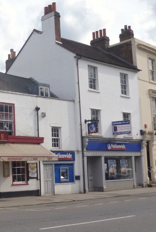
Late C18 - early C19. Stuccoed. 3 storeys. 2 windows. Ground floor occupied by
shop front (fishmonger's). Sash windows with glazing bars intact. Tiled roof
Photograph in NMR.
Nos 132 to 156 (even) and Nos 164 to 170 (even) form a group.
Nos 164 and 166 shall be amended to read Nos 162 and 164
The group value note should be amended to read
Nos 132 to 156 (even), 162, 164, 168 and 170 form a group.
The group value note appearing against entries for Nos 132 to 156 (even), 168 and
170, High Street
should be amended to read
Nos 132 to 156 (even) 162, 164 168 and 170 form a group.
------------------------------------
HIGH STREET
1.
1049
(South-East Side)
Nos 164 and 166
TQ 1649 SE 1/159
II GV
2.
Late C18 - early C19. Stuccoed. 3 storeys. 2 windows. Ground floor occupied
by shop front (fishmonger's). Sash windows with glazing bars intact. Tiled
roof. Photograph in NMR.
Nos 132 to l56 (even) and Nos l64 to 170 (even) form a group.
Listing NGR: TQ1671149491
External links are from the relevant listing authority and, where applicable, Wikidata. Wikidata IDs may be related buildings as well as this specific building. If you want to add or update a link, you will need to do so by editing the Wikidata entry.


Other nearby listed buildings
