Approximate Location Map
Large Map »
Latitude: 54.0496 / 54°2'58"N
Longitude: -2.8039 / 2°48'13"W
OS Eastings: 347464
OS Northings: 461819
OS Grid: SD474618
Mapcode National: GBR 8PVM.R2
Mapcode Global: WH846.WGZT
Plus Code: 9C6V25XW+VC
Entry Name: 9, Castle Hill
Listing Date: 18 February 1970
Last Amended: 13 March 1995
Grade: II
Source: Historic England
Source ID: 1290848
English Heritage Legacy ID: 383068
ID on this website: 101290848
Location: Lancaster, Lancashire, LA1
County: Lancashire
District: Lancaster
Electoral Ward/Division: Castle
Parish: Non Civil Parish
Built-Up Area: Lancaster
Traditional County: Lancashire
Lieutenancy Area (Ceremonial County): Lancashire
Church of England Parish: Lancaster St Mary with St John and St Anne
Church of England Diocese: Blackburn
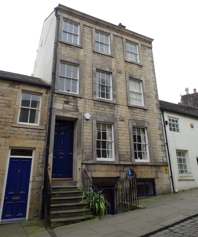
LANCASTER
SD4761NW CASTLE HILL
1685-1/6/35 (East side)
18/02/70 No.9
(Formerly Listed as:
CASTLE HILL
(South East side)
Nos.9 AND 9A)
GV II
House, now flats and shop. Late C18, altered and partly
rebuilt c1975 and perhaps originally the right-hand half of a
pair. Sandstone ashlar facade in narrow courses with plain
quoins, with rebuilt coursed rubble to the rear and sides,
rendered on the left. Composition tile roof with gable chimney
to the right.
3 storeys above a tall basement, expressed as a plinth with
deep coursed stonework, and 3 bays under an eaves cornice. The
windows, which have 12-pane sashes, some recent replacements,
have raised plain surrounds with a sill band on the ground
floor and, on second floor, lintels linked into a band below
the cornice. The doorway, on the far left, also has a raised
plain surround and is reached up a flight of 6 nosed steps
with iron railings on both sides. The deeply-recessed door
originally had 9 raised and fielded panels, but the top panels
are now glazed. To the right of the doorway is the original
entrance to the basement and the shop, now down steps but
originally through a trap door. The rear has a recent
ground-floor extension and a wide very tall staircase window
to the right.
Listing NGR: SD4746461819
External links are from the relevant listing authority and, where applicable, Wikidata. Wikidata IDs may be related buildings as well as this specific building. If you want to add or update a link, you will need to do so by editing the Wikidata entry.


Other nearby listed buildings
