Approximate Location Map
Large Map »
Latitude: 54.1562 / 54°9'22"N
Longitude: -3.1857 / 3°11'8"W
OS Eastings: 322664
OS Northings: 474020
OS Grid: SD226740
Mapcode National: GBR 6N6C.3W
Mapcode Global: WH72B.1S8P
Plus Code: 9C6R5R47+FP
Entry Name: Numbers 2, 3 and 4 and Attached Stable
Listing Date: 6 May 1976
Last Amended: 20 December 1993
Grade: II
Source: Historic England
Source ID: 1292062
English Heritage Legacy ID: 388491
ID on this website: 101292062
Location: Dalton-in-Furness, Westmorland and Furness, Cumbria, LA15
County: Cumbria
District: Barrow-in-Furness
Civil Parish: Dalton Town with Newton
Built-Up Area: Dalton-in-Furness
Traditional County: Lancashire
Lieutenancy Area (Ceremonial County): Cumbria
Church of England Parish: Dalton-in-Furness St Mary
Church of England Diocese: Carlisle
Tagged with: Building
BARROW IN FURNESS
SD2274 KING'S MOUNT, Dalton In Furness
708-1/10/169 Nos.2, 3 AND 4
06/05/76 and attached stable
(Formerly Listed as:
KING'S MOUNT, Dalton
Nos.2-4 (Consecutive))
GV II
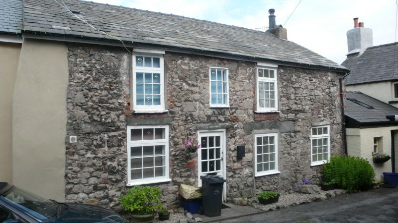
Row of houses and stable. Early-mid C19. Roughcast over
limestone, slate roofs. 2 storeys and attic, 1:2:2 windows to
1st floor. Nos 3 & 4 on right are a semi-detached pair each
with door on left of window to each floor. No.3: part-glazed
door and blocked overlight beneath slated canopy; projecting
stone sills and raised surrounds to 12-pane sashes. No.4:
boarded door and overlight, plain sashes. Truncated end
stacks, central ridge stack. No.2 is set back on left, lower
and of earlier date: door to right of centre flanked, on left,
by casement under segmental arch and, on right, by 4-pane
sash; two 16-pane sashes to 1st floor; central dormer with
pair of incomplete casements beneath gable; end stack on left.
Stable adjoining No.2 on left is of exposed stone with large
quoins: casement and stable door under red sandstone arches;
taking-in door now glazed. On passage that runs between Nos 18
& 19 Market Place (qv). The passage is marked 'Court No. 3'
and together with Nos 19A & 19B Market Place (qv) these
buildings illustrate secondary development on narrow plots
behind the prestigious Market Place frontage. Stable shown as
1 King's Mount on OS map.
Listing NGR: SD2266474020
External links are from the relevant listing authority and, where applicable, Wikidata. Wikidata IDs may be related buildings as well as this specific building. If you want to add or update a link, you will need to do so by editing the Wikidata entry.


Other nearby listed buildings
