Approximate Location Map
Large Map »
Latitude: 52.468 / 52°28'4"N
Longitude: -1.2105 / 1°12'37"W
OS Eastings: 453733
OS Northings: 285855
OS Grid: SP537858
Mapcode National: GBR 8PH.6SG
Mapcode Global: VHCTC.Y7YC
Plus Code: 9C4WFQ9Q+6R
Entry Name: Church of St Mary
Listing Date: 11 January 1955
Grade: II*
Source: Historic England
Source ID: 1292319
English Heritage Legacy ID: 392504
ID on this website: 101292319
Location: St Mary's Church, Harborough, Leicestershire, LE17
County: Leicestershire
District: Harborough
Civil Parish: Bitteswell with Bittesby
Built-Up Area: Lutterworth
Traditional County: Leicestershire
Lieutenancy Area (Ceremonial County): Leicestershire
Church of England Parish: Bitteswel St Mary
Church of England Diocese: Leicester
Tagged with: Church building
BITTESWELL
LUTTERWORTH ROAD
SP58NW
1323-0 3/15 (North side)
11/01/55 Church of St Mary
II*
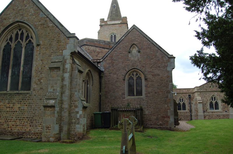
Church. C13 and C14, extended 1852 by W Parsons and altered
and extended by Walter F Lyon in 1881-82. Random rubble stone
with dressed quoins, gable parapets and crenellated side
parapets to nave. Plain slate roofs. West tower, nave with
south porch and north aisle, north vestry and chancel.
Three-stage tower of C13/C14 with stepped angle buttresses.
Deep recess on north side of tower with Perpendicular-style
panelled soffit and hollow-chamfered arch. Short recessed
spire. two-light square-headed belfry openings. Nave with
three windows to south of C14, restored in C19. Aisle to north
of 1881-82. Gabled south porch with double chamfers to arch
and dripmould. Chancel rebuilt in 1881-82, two windows to
south and vestry to north. Interior: double chamfered C14
tower arch. Three-bay north aisle with double-chamfered arcade
on octagonal piers. Ceiling probably C19 with ribs and
flattish vault. C19 chancel arch, double-chamfered on attached
octagonal piers. Triple-chamfered round arch inside tower,
west of tower arch, purpose unknown. Fittings: benches, font,
pulpit, all C19.
(The Buildings of England: Pevsner N, Williamson E, Brandwood
G: Leicestershire and Rutland: London: 1984-: 103).
Listing NGR: SP5373385855
External links are from the relevant listing authority and, where applicable, Wikidata. Wikidata IDs may be related buildings as well as this specific building. If you want to add or update a link, you will need to do so by editing the Wikidata entry.


Other nearby listed buildings
