Approximate Location Map
Large Map »
Latitude: 52.6311 / 52°37'52"N
Longitude: -1.6865 / 1°41'11"W
OS Eastings: 421318
OS Northings: 303756
OS Grid: SK213037
Mapcode National: GBR 5GY.0GF
Mapcode Global: WHCH4.2467
Plus Code: 9C4WJ8J7+FC
Entry Name: Bolehall Viaduct
Listing Date: 9 November 1972
Grade: II
Source: Historic England
Source ID: 1293304
English Heritage Legacy ID: 386490
Also known as: Anker Viaduct
19 Arches
Kettlebrook Viaduct
ID on this website: 101293304
Location: Tamworth, Staffordshire, B77
County: Staffordshire
District: Tamworth
Electoral Ward/Division: Bolehall
Parish: Non Civil Parish
Built-Up Area: Tamworth
Traditional County: Warwickshire
Lieutenancy Area (Ceremonial County): Staffordshire
Church of England Parish: Tamworth St Editha
Church of England Diocese: Lichfield
Tagged with: Viaduct Railway viaduct
TAMWORTH
SK2103SW GLASCOTE ROAD, Bolehall
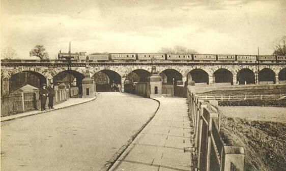
670-1/10/15 Bolehall Viaduct
09/11/72
GV II
Also known as: Bolebridge Viaduct GLASCOTE ROAD Bolehall.
Railway Viaduct. 1837-9. R.Stephenson and G.Bidder, engineers;
for Birmingham and Derby Junction Railway. Rusticated ashlar.
19 arches; nos 6 and 7 span River Anker; no 10 spans Amington
Road; no 19 is lower and wider and spans Glascote Road.
Rusticated segmental arches; piers have rock-faced jambs,
round cutwaters to river; bold modillioned cornice and
parapet; abutments swept forward. 2 arches have low stone
walls flanking entrance gates. An important landmark at the
south east end of Tamworth.
(A Regional History of the Railways of Great Britain:
Christiansen R: The West Midlands: London: 1973-: P.136-7).
Listing NGR: SK2131803756
External links are from the relevant listing authority and, where applicable, Wikidata. Wikidata IDs may be related buildings as well as this specific building. If you want to add or update a link, you will need to do so by editing the Wikidata entry.


Other nearby listed buildings
