Approximate Location Map
Large Map »
Latitude: 51.4053 / 51°24'19"N
Longitude: -0.4094 / 0°24'33"W
OS Eastings: 510733
OS Northings: 168566
OS Grid: TQ107685
Mapcode National: GBR 3Y.9GF
Mapcode Global: VHFTR.VYF2
Plus Code: 9C3XCH4R+46
Entry Name: Wall Along Thames Street and Forming East Boundary of Churchyard of Church of St Mary the Virgin
Listing Date: 24 September 1987
Grade: II
Source: Historic England
Source ID: 1294948
English Heritage Legacy ID: 288035
ID on this website: 101294948
Location: Spelthorne, Surrey, TW16
County: Surrey
District: Spelthorne
Electoral Ward/Division: Sunbury East
Parish: Non Civil Parish
Built-Up Area: Walton-on-Thames
Traditional County: Middlesex
Lieutenancy Area (Ceremonial County): Surrey
Church of England Parish: St Mary Sunbury-on-Thames
Church of England Diocese: London
Tagged with: Wall
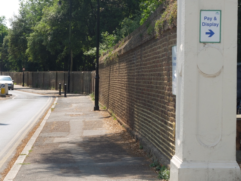
TQ 16NW SUNBURY-ON-THAMES, FORMER UD THAMES STREET
Sunbury
4/64 Wall along Thames
Street and forming
east boundary of
Churchyard of Church
of St. Mary the
Virgin
GV II
Walls. C18 and C19. Red brick on the wall forming the eastern boundary of the
churchyard. Approx. 6 feet high and extending for 20 metres at right angles to
Thames Street. Square pier, approximately 9 feet high on pedestal at junction
of two ranges. Brown brick wall extending along Thames Street with plinth and
pier buttresses, approximately 6 feet high and then stepping up to 6½ feet after
20 metres and with stone coping. Further stretch of approx. 70 metres with no
coping to square, red brick pier approx. 8 feet high. Wall then continues with
offset coping to stone gate piers with moulded plinths and caps.
A prominent feature of the street.
Listing NGR: TQ1073368566
External links are from the relevant listing authority and, where applicable, Wikidata. Wikidata IDs may be related buildings as well as this specific building. If you want to add or update a link, you will need to do so by editing the Wikidata entry.


Other nearby listed buildings
