Approximate Location Map
Large Map »
Latitude: 54.8927 / 54°53'33"N
Longitude: -2.9366 / 2°56'11"W
OS Eastings: 340021
OS Northings: 555726
OS Grid: NY400557
Mapcode National: GBR 7CYV.0X
Mapcode Global: WH802.V9S1
Plus Code: 9C6VV3V7+38
Entry Name: Numbers 10-22 Incorporating City Walls
Listing Date: 11 April 1994
Grade: I
Source: Historic England
Source ID: 1297278
English Heritage Legacy ID: 386912
ID on this website: 101297278
Location: Carlisle, Cumberland, Cumbria, CA3
County: Cumbria
District: Carlisle
Parish: Non Civil Parish
Built-Up Area: Carlisle
Traditional County: Cumberland
Lieutenancy Area (Ceremonial County): Cumbria
Church of England Parish: Carlisle St Cuthbert with St Mary
Church of England Diocese: Carlisle
Tagged with: Architectural structure
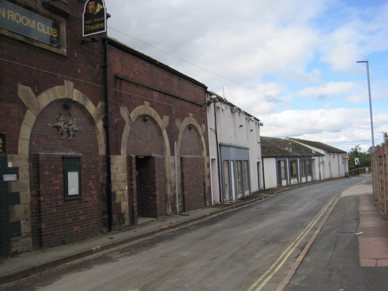
CARLISLE
NY3956SE WEST WALLS
671-1/6/309 (West side)
Nos.10-22 (Even)
incorporating city walls
GV I
City wall, mews stables, warehouses and school; now theatre,
public house, amusement arcade and disco. Early C12 city wall,
1813 school, late C19 mews and 1980s public house, etc. These
later buildings in themselves are not of interest but are
listed to protect the city wall behind them.
The front wall of each building on the West Walls facade being
built on top of the west city walls. Robert Smirke suggested
that buildings could be built against the walls when he
advised on the building of the Central School; see
correspondence in Cumbria County Record Office, Ca/2/209/76
and Ca/5/3/39, and conveyances of the School 1919-20 as St
Cuthbert's Parish Hall (the school closed 31 August 1909)
Ca/5/2/40.
That the city wall exists behind these buildings was confirmed
by work done by the Carlisle Archaeological Unit in recording
the structure when "Legends" and "Big Softies" were extended
in 1985. For the through-archway and chamber behind the wall,
thought to be the sewerage outlet for Blackfriars Convent, now
within the Green Room Theatre, see W Hutchinson (1794);
Carlisle Journal (1829); and Lysons Magna Britannia:
Cumberland (1816), for drawings of the chamber.
This stretch of city walls does not form part of the Scheduled
Ancient Monument of the remaining exposed West Walls, but is a
continuation of it. For the further continuation of this wall
see under the Central Plaza Hotel, Victoria Viaduct (qv).
(Carlisle Journal: 7 February 1829; Lysons: Magna Britannia;
Cumberland: 1816-: P.CCVII; Hutchinson, William: History of
Cumberland: 1794-: P.607).
Listing NGR: NY4002155726
External links are from the relevant listing authority and, where applicable, Wikidata. Wikidata IDs may be related buildings as well as this specific building. If you want to add or update a link, you will need to do so by editing the Wikidata entry.


Other nearby listed buildings
