Approximate Location Map
Large Map »
Latitude: 52.373 / 52°22'22"N
Longitude: -1.2622 / 1°15'43"W
OS Eastings: 450325
OS Northings: 275246
OS Grid: SP503752
Mapcode National: GBR 7P7.CNX
Mapcode Global: VHCTR.2MK7
Plus Code: 9C4W9PFQ+54
Entry Name: Clock Tower
Listing Date: 3 September 1976
Grade: II
Source: Historic England
Source ID: 1300276
English Heritage Legacy ID: 308492
ID on this website: 101300276
Location: Rugby, Warwickshire, CV21
County: Warwickshire
District: Rugby
Electoral Ward/Division: Eastlands
Parish: Non Civil Parish
Built-Up Area: Rugby
Traditional County: Warwickshire
Lieutenancy Area (Ceremonial County): Warwickshire
Church of England Parish: Rugby St Andrew
Church of England Diocese: Coventry
Tagged with: Clock tower
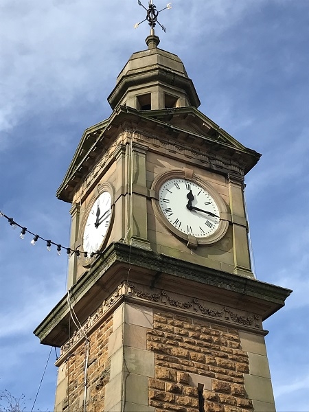
MARKET PLACE
1.
5397
(Centre)
Clock Tower
SP 5075 SW 1/132
II
2.
1887 in honour of Queen Victoria's Jubilee. Square plan, 3 stages. Ashlar plinth,
shaft of block in course hammer dressed stone. Clock in pedimented ashlar surround
with Doric pilasters and octagonal ashlar cupola.
Listing NGR: SP5032575246
External links are from the relevant listing authority and, where applicable, Wikidata. Wikidata IDs may be related buildings as well as this specific building. If you want to add or update a link, you will need to do so by editing the Wikidata entry.


Other nearby listed buildings
