Approximate Location Map
Large Map »
Latitude: 53.9124 / 53°54'44"N
Longitude: -1.7418 / 1°44'30"W
OS Eastings: 417058
OS Northings: 446284
OS Grid: SE170462
Mapcode National: GBR JR86.P7
Mapcode Global: WHC8Q.6XTJ
Plus Code: 9C5WW765+X7
Entry Name: Wall around ground south of mill pond, along Main Street east of Malt Shovel and along west side of Corn Hill Lane
Listing Date: 20 May 1976
Grade: II
Source: Historic England
Source ID: 1300943
English Heritage Legacy ID: 337659
ID on this website: 101300943
Location: Burley in Wharfedale, Bradford, West Yorkshire, LS29
County: Bradford
Civil Parish: Burley
Built-Up Area: Burley in Wharfedale
Traditional County: Yorkshire
Lieutenancy Area (Ceremonial County): West Yorkshire
Church of England Parish: Burley-in-Wharfedale St Mary the Blessed Virgin
Church of England Diocese: Leeds
Tagged with: Wall
This list entry was subject to a Minor Amendment on 2 June 2023 to update the group value statement and to reformat the text to current standards
SE 1746
8/113
Burley in Wharfedale
MAIN STREET (North Side) LS29 7DN
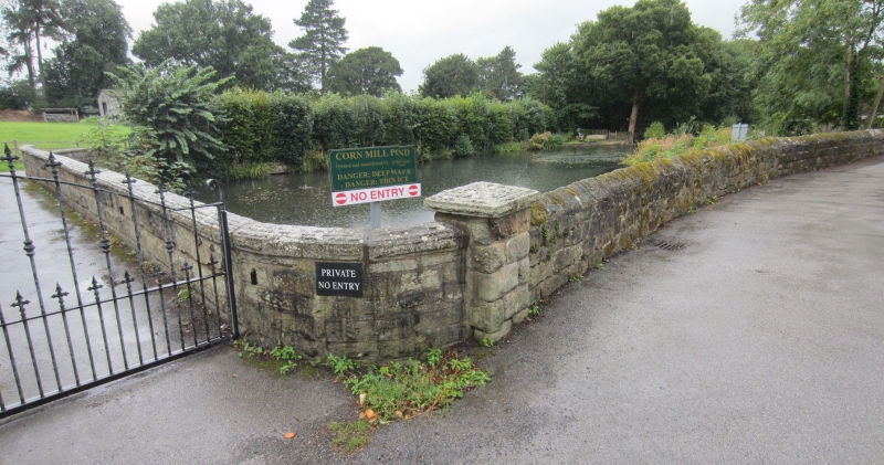
Wall around ground south of mill pond, along Main Street east of Malt Shovel and along west side of Corn Hill Lane.
GV
II
Low wall perhaps early C19. At west end, adjoining the Malt Shovel is a short castellated section of about 6 ft and having a blind ogee arch, arrow slit and mounting steps (all perhaps contemporary with the Malt Shovel). Remaining stretch along Main Street is low, with semi-circular coping. Along Corn Mill Lane (to wall of viaduct) it is also low, but with peaked coping.
Burley Lodge, No 2 (Highway Cottage) and Chevin House, Nos 4 to 16 (even), Nos 24 to 30 (even) and 30A, 2 Post Office Yard, St Mary's Church, wall around ground south of mill pond (along Main Street and west side of Corn Mill Lane), and the Malt Shovel Hotel, form a group.
Listing NGR: SE1705846284
External links are from the relevant listing authority and, where applicable, Wikidata. Wikidata IDs may be related buildings as well as this specific building. If you want to add or update a link, you will need to do so by editing the Wikidata entry.


Other nearby listed buildings
