Approximate Location Map
Large Map »
Latitude: 50.5901 / 50°35'24"N
Longitude: -2.4246 / 2°25'28"W
OS Eastings: 370040
OS Northings: 76798
OS Grid: SY700767
Mapcode National: GBR PZ.0RBX
Mapcode Global: FRA 57TH.TGP
Plus Code: 9C2VHHRG+35
Entry Name: Bincleaves groyne and the north-eastern breakwater
Listing Date: 22 December 1997
Last Amended: 26 February 2018
Grade: II
Source: Historic England
Source ID: 1313401
English Heritage Legacy ID: 467251
ID on this website: 101313401
Location: Portland Harbour, Dorset, DT4
County: Dorset
Electoral Ward/Division: Weymouth East
Parish: Non Civil Parish
Traditional County: Dorset
Lieutenancy Area (Ceremonial County): Dorset
Church of England Parish: Weymouth Holy Trinity
Church of England Diocese: Salisbury
Tagged with: Architectural structure Breakwater
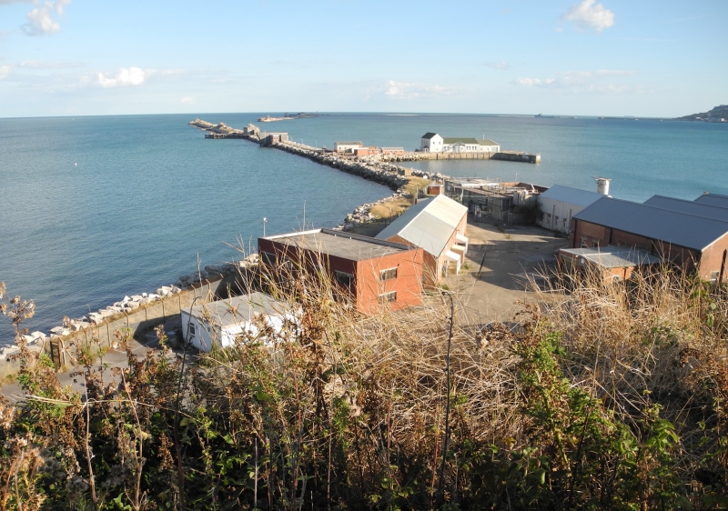
Two breakwaters, known as Bincleaves groyne and the north-eastern breakwater, enclosing Portland Harbour. Built between 1893 and 1906. C20 alterations and additions. All post-1945 building, structures and plant added to the structures are excluded from the listing.
Two breakwaters, known as Bincleaves groyne and the north-eastern breakwater, enclosing Portland Harbour. Built between 1893 and 1906. C20 alterations and additions. All post-1945 building, structures and plant added to the structures are excluded from the listing.
MATERIALS: constructed of large blocks of Portland stone, with granite facings to the circular pierheads.
PLAN: two sections of breakwater, each approximately 1.3km long and separated by the north ship channel. Each of the three pierheads is circular, and has a diameter of approximately 30m.
DESCRIPTION: the battered seaward side of each breakwater is of large bolstered stone blocks. The inner face of the elevated road is faced with coursed blocks of Portland stone, and the lower road is bordered by piles of large Portland stone blocks. Each of the circular pierheads has a stone staircase on its inner face, and bollards and winches associated with the boom. Halfway along the length of each breakwater is a landing stage.
Features of note on the NORTH-EASTERN BREAKWATER include the lighthouse, a 22m cast-iron structure comprising a skeletal, hexagonal frame around a central cylinder with a domed lantern by Chance Brothers & Co., and the concrete circular gun platform and holdfast of a rare First World War 3-inch 20cwt anti-aircraft gun, with four ammunition lockers.
Features of note on BINCLEAVES GROYNE include the early C20 coastal battery and the long and short range torpedo firing ranges. The early C20 building associated with the short range torpedo pier has been clad in corrugated iron and is substantially altered.
Both breakwaters retain First and Second World War observation posts and searchlights of concrete and brick, and 29mm spigot mortar gun emplacements.
Pursuant to s1 (5A) of the Planning (Listed Buildings and Conservation Areas) Act 1990 (‘the Act’) it is declared that all post-1945 buildings, structures and plant added to Bincleaves groyne and the north-eastern breakwater are not of special architectural or historic interest.
The area around Portland Harbour has historically been recognised as an important military strategic location. The advent of a steam-driven naval fleet in the early to mid-C19 necessitated the storage of large quantities of coal, not only at the dockyards, but also at strategic locations determined by the likelihood of enemy attack and the limited range of the steamship when using its engines alone. Portland, conveniently situated equidistant between Portsmouth and Plymouth and facing the French naval dockyard at Cherbourg, was established as the first naval anchorage specifically designed for the navy’s fleet of steam-driven warships, and the necessary breakwaters and coaling facilities were an integral part of the scheme. Suggestions for fortifying the anchorage here were first put forward in 1835. An 1844 survey map of Portland, by surveyor John Taperell, shows the proposed breakwater structures of the scheme designed by the Admiralty’s Chief Engineer, James Meadow Rendel. Preliminary works for the breakwaters began in 1847 with the formal construction of the inner breakwater being marked by a ceremony in which HRH Prince Albert laid the foundation stone on 25 July 1849.
The inner and outer breakwater at the southern end of the harbour created a harbour of refuge for the navy’s fleet of steam-driven warships, but in the late C19 the fear of torpedo and submarine attack rose and plans were developed to create two further breakwaters to the north, enclosing the harbour. Initially, between 1893 and 1896, a line of dolphins (man-made structures of timber and iron that extend above the waterline) with nets between them were constructed between Bincleaves Rocks and the outer breakwater fort, at the north end of the outer breakwater. Plans for more substantial defences were developed, and between 1896 and 1906 the two breakwaters, Bincleaves groyne and the north-eastern breakwater, were constructed. By 1929 an artificial land mass was created in front of Bincleaves Rocks, absorbing the western extent of Bincleaves groyne. Each of the three pierheads had a coastal battery armed with two, 12-pounder quick-firing guns. A navigational light was added to two of the pierheads, and in 1905 a lighthouse was built at the pierhead guarding the north ship channel, with a lantern supplied by Chance Brothers & Co. a well-known lighthouse engineering company. Originally lit by oil, it was later converted to gas, and was automated in the late 1960s. The lighthouse was restored in 2016.
A short range torpedo firing range (1899 to 1901) testing the torpedoes manufactured at Robert Whitehead’s torpedo works in Wyke Regis was built to the south side of Bincleaves groyne on a separate man-made island; this was later joined to Bincleaves groyne. By 1918 a long range torpedo firing range was operating on the north side of the breakwater. During the First World War, torpedo stations were added to each pierhead, as well as brick and concrete battery observation posts. And, halfway along the length of the north-eastern breakwater is a rare example of a First World War gun emplacement for the QF 3-inch 20 cwt anti-aircraft gun. During the Second World War further observation posts and searchlights were added, as well as 29mm spigot mortar gun emplacements and anti-aircraft gun emplacements. Both breakwaters were developed with gun-crew shelters, latrines, and cookhouses but most of these buildings have been demolished.
Bincleaves groyne and the north-eastern breakwater are listed at Grade II for the following principal reasons:
Architectural interest:
* The huge and impressive engineering feat of constructing the breakwaters;
* A continuation of the design characteristics of the inner and outer breakwater;
* The overall survival and retention of features such as the early C20, cast-iron lighthouse which includes the lantern by Chance Brothers & Co.
Historic interest:
* For their construction in response to the rising fear of torpedo attack in the late C19 and early C20;
* The relationship with the manufacture and development of torpedoes at Portland Harbour and the incorporation of the short and long range torpedo firing range for testing;
* A rare survival of a First World War gun emplacement for the QF 3-inch 20 cwt anti-aircraft gun on the north-eastern breakwater;
Group value:
* As part of a largely complete naval base of considerable importance;
* With the Grade II listed mid-C19 inner and outer breakwater to the south of the harbour.
External links are from the relevant listing authority and, where applicable, Wikidata. Wikidata IDs may be related buildings as well as this specific building. If you want to add or update a link, you will need to do so by editing the Wikidata entry.


Other nearby listed buildings
