Approximate Location Map
Large Map »
Latitude: 53.6788 / 53°40'43"N
Longitude: -1.7336 / 1°44'0"W
OS Eastings: 417695
OS Northings: 420297
OS Grid: SE176202
Mapcode National: GBR JTBW.HZ
Mapcode Global: WHC9W.BSQL
Plus Code: 9C5WM7H8+GH
Entry Name: Calder and Hebble Navigation Number 2 Lock Sir John Ramsdens Canal Number 2 Lock
Listing Date: 29 September 1978
Grade: II
Source: Historic England
Source ID: 1313801
English Heritage Legacy ID: 339640
ID on this website: 101313801
Location: Colne Bridge, Kirklees, West Yorkshire, HD5
County: Kirklees
Electoral Ward/Division: Ashbrow
Parish: Non Civil Parish
Built-Up Area: Huddersfield
Traditional County: Yorkshire
Lieutenancy Area (Ceremonial County): West Yorkshire
Church of England Parish: Bradley St Thomas
Church of England Diocese: Leeds
Tagged with: Lock
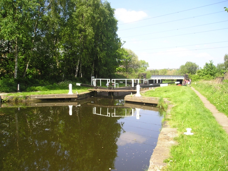
CALDER AND HEBBLE NAVIGATION
1.
5113
SIR JOHN RAMSDEN'S CANAL
No 2 Lock
SE 1720 13/293
II
2.
1774-80. Ashlar kerbstones. Iron mooring hooks. 2 wooden lock gates.
Listing NGR: SE1769520296
External links are from the relevant listing authority and, where applicable, Wikidata. Wikidata IDs may be related buildings as well as this specific building. If you want to add or update a link, you will need to do so by editing the Wikidata entry.


Other nearby listed buildings
