Approximate Location Map
Large Map »
Latitude: 53.7085 / 53°42'30"N
Longitude: -1.9118 / 1°54'42"W
OS Eastings: 405920
OS Northings: 423571
OS Grid: SE059235
Mapcode National: GBR HT2K.XB
Mapcode Global: WHB8N.L1VS
Plus Code: 9C5WP35Q+C7
Entry Name: Former Lloyds Bank
Listing Date: 19 July 1988
Grade: II
Source: Historic England
Source ID: 1319977
English Heritage Legacy ID: 339413
ID on this website: 101319977
Location: Friendly, Calderdale, West Yorkshire, HX6
County: Calderdale
Electoral Ward/Division: Sowerby Bridge
Parish: Non Civil Parish
Built-Up Area: Halifax
Traditional County: Yorkshire
Lieutenancy Area (Ceremonial County): West Yorkshire
Church of England Parish: Sowerby Bridge Christ Church
Church of England Diocese: Leeds
Tagged with: Bank building
This list entry was subject to a Minor Amendment on 19 May 2021 to update the name and address and reformat the text to current standards
SE 0423 and SE 0523
12/281
SOWERBY BRIDGE
TOWN HALL STREET (north side)
No 9
Former Lloyds Bank
(Formerly listed as Lloyds Bank, TOWN HALL STREET)
GV
II
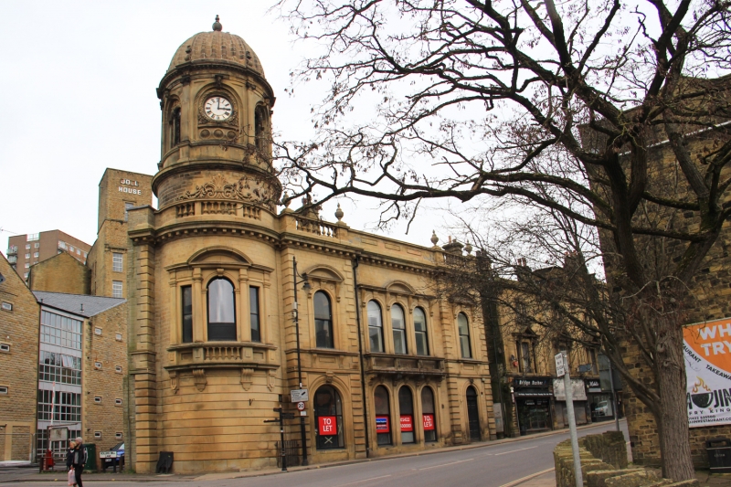
Former bank. Probably 1870s. Ashlar, roof not visible. Two storeys, three bays plus rounded corner bay rising as two-stage tower. Italianate style. Plinth, bays defined by rusticated quoins, punch-dressed to ground floor. Tall round-arched openings. Central bay has a triple window to each floor, the lights separated by pilasters and with keystones and bracketed cornices. The first floor window is more elaborate and has balcony and segmental pediment over central light. Outer bays break forward slightly. Each has doorway, that to left now window, with keyed moulded architrave and window above with bracketed cill and consoled segmental pediment. Dentilled cornice. Parapet, balustraded over outer bays, with coping and vase finials. Stacks between bays one and two and to right end. Tower on left: first stage (the height of ground and first floors) has rusticated stone to lower half and Venetian window to upper half with colonnettes, pilasters, balustrade on consoles, cornice and segmental pediment. Cornice as main block; balustrade with elaborate festoon over centre; cornice. Top stage has six faces, separated by Ionic pilasters, each with an arched niche with elaborate architrave and head keystone. South west niche has clock in leaf surround; other niches each have a two-light opening with colonnettes and decorative iron grilles and tympanum. Entablature with dentil cornice. Ribbed stone dome with pilasters rising into brackets supporting central finial.
The building was formerly the Town Hall, although it was never in fact owned by the town. when originally built it had a symmetrical plan with a balancing wing returning along Hollins Mill Lane (now demolished). The clock was paid for by public subscription (Civil Society, p5).
Listing NGR: SE0592023571
External links are from the relevant listing authority and, where applicable, Wikidata. Wikidata IDs may be related buildings as well as this specific building. If you want to add or update a link, you will need to do so by editing the Wikidata entry.


Other nearby listed buildings
