Approximate Location Map
Large Map »
Latitude: 51.7512 / 51°45'4"N
Longitude: -1.2469 / 1°14'48"W
OS Eastings: 452085
OS Northings: 206105
OS Grid: SP520061
Mapcode National: GBR 8Z4.3LG
Mapcode Global: VHCXV.B7PV
Plus Code: 9C3WQQ23+F6
Entry Name: The Library and Herbarium of the Botanic Gardens
Listing Date: 12 January 1954
Grade: I
Source: Historic England
Source ID: 1320377
English Heritage Legacy ID: 245495
ID on this website: 101320377
Location: University Botanical Garden, Headington Hill, Oxford, Oxfordshire, OX1
County: Oxfordshire
District: Oxford
Electoral Ward/Division: Holywell
Parish: Non Civil Parish
Built-Up Area: Oxford
Traditional County: Oxfordshire
Lieutenancy Area (Ceremonial County): Oxfordshire
Church of England Parish: Oxford St Mary the Virgin with St Cross with St Peter-in-the-East,
Church of England Diocese: Oxford
Tagged with: Library building
HIGH STREET
1.
1485
(South Side)
Botanic Gardens
The Library and
Herbarium of the
Botanic Gardens
SP 5206 SW 10/422 12.1.54.
I GV
2.
The Library and Herbarium consists of 2 buildings, now including Magdalen
College Bursaey.
(a) The South elavation was originally of one storey built to form the eastern-most
orangery, or plant house, in 1733-35 for which William Townesend, the Oxford
mason-architect, was paid in 1736. It was raised by one storey when H J
Underwood designed the porter's lodge on the west and (b) the North elevation.
The South elevation now consists of 2-storeyed ashlar with a moulded cornice
at the 1st floor and a parapet with a moulded cornice below it. There is
a 2-storeyed 3-sided bay with a central doorway flanked by a window. The
tall sash windows have plain recessed reveals and rusticated keystones. The
additional storey of C1835 is in the same style; at this time the building
became the Professor's house.
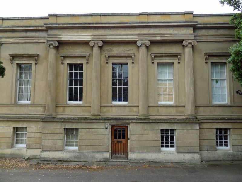
(b) The North elevation, c.1835 by Underwood is 2-storeyed ashlar on a rusticated
ground floor and having a centre piece of 4 engaged Doric columns breaking
forward, a moulded entablature and a parapet. 5 tall sash windows in moulded
frames with scroll bracketed cornices: in the ground floor are 5 small sash
windows.
All the listed bui1dings on the South Side form a group.
Listing NGR: SP5208606106
External links are from the relevant listing authority and, where applicable, Wikidata. Wikidata IDs may be related buildings as well as this specific building. If you want to add or update a link, you will need to do so by editing the Wikidata entry.


Other nearby listed buildings
